|
1
|
ARP coordinates and site at AD
|
525525N 0044650E
299° GEO 294 M from TWR. |
|
2
|
Direction and distance from (city)
|
2.9 NM S of Den Helder
|
|
3
|
Elevation / reference temperature
|
ELEV: 4 FT AMSL / T: 19.6 °C
|
|
4
|
Geoid undulation at AD ELEV PSN
|
138 FT
|
|
5
|
MAG VAR / annual change
|
2.4° E (2025) / 0.2° E
|
|
6
|
AD operator, address, telephone, telefax, email address, AFS, URL
|
DEN HELDER AIRPORT
Luchthavenweg 10a 1786 PP DEN HELDER THE NETHERLANDS TEL: +31 (0)223 635 666 email: [email protected] URL: https://www.denhelderairport.nl |
|
7
|
Types of traffic permitted (IFR/VFR)
|
IFR/VFR
|
|
8
|
Remarks
|
- For requests regarding UAS operations within EHKD CTR contact: - Email: [email protected] - Military administration - Post: DHC Maritiem Vliegkamp De Kooy MPC 10A P.O. Box 8762 4820 BB Breda The Netherlands - TEL: +31 (0)88 956 3130 (Airfield Manager, MON-FRI 0700-1530 (MON-FRI 0600-1430)) - TEL: +31 (0)88 958 3310 (ATC, AD OPR HR only) - TEL: +31 (0)88 958 3300 (LCC, outside AD OPR HR) - Email: [email protected] - AFS: EHKDZTZX |
|
1
|
Use of aircraft stand ID signs, TWY guide lines and visual docking/parking guidance system at aircraft stands
|
- Follow-me car AVBL O/R to guide visiting aircraft from the runway to the parking area and vice versa.
- Civil apron, parking spots 2 to 12: ICAO standard heliport spot marking, apron aircraft stands, TWY centre line. |
|
2
|
RWY and TWY markings and LGT
|
RWY markings
- threshold, aiming point RWY 03, centre line, RWY designations, helipads HP 1, 2, 3 and 4 marked. RWY LGT - threshold, wing bar RWY 03, edge and end lights. TWY marking - holding points, retroreflective centre line markers TWY L, helipad HP 5 (on TWY D) marked. TWY LGT - centre line lights TWY D1, edge lights, helipad HP 5 LGT. |
|
3
|
Stop bars
|
NIL
|
|
4
|
Remarks
|
- Dispite LVP operations, holding position lights and runway guard lights not available.
- RWY 03/21: no intersection take-off signs available; values available on request to ATC. |
|
1
|
Associated MET office
|
DE BILT
|
|
2
|
Hours of service
MET office outside hours |
Hours of service
H24 MET office outside hours NIL |
|
3
|
Office responsible for TAF preparation
Period of validity |
Woensdrecht (Joint Meteorological Group)
12 HR |
|
4
|
Trend forecast
Interval of issuance |
TREND
Every 30 MIN during AD OPR HR. |
|
5
|
Briefing/consultation provided
|
Briefing on request from MWO-De Bilt by telephone after self-briefing.
TEL: 0900 202 3341 Briefing low level flights (IFR/VFR). TEL: 0900 202 3343 Briefing IFR flights above FL 100. TEL: 0900 202 3340 Briefing balloon flights within Amsterdam FIR. Weather bulletin (Dutch language) and METARs via Dutch public TV Teletekst page 707. |
|
6
|
Flight documentation
Language(s) used |
Reports, forecast.
English, Dutch. |
|
7
|
Charts and other information available for briefing or consultation
|
S, P, W, T
|
|
8
|
Supplementary equipment available for providing information
|
WXR, APT
|
|
9
|
ATS units provided with information
|
RAPCON West, De Kooy Arrival, De Kooy TWR.
|
|
10
|
Additional information (limitation of service, etc.)
|
Briefing/consultation provided
- charge for TEL briefings and consultations is € 0,50/MIN. |
|
RWY designation
|
True BRG
|
Dimensions of RWY (M)
|
Strength (PCN) and surface of RWY and SWY
|
THR coordinates
RWY end coordinates THR GUND |
THR ELEV and highest ELEV of TDZ of precision APCH RWY
|
|---|---|---|---|---|---|
|
1
|
2
|
3
|
4
|
5
|
6
|
|
03
|
033.91°
|
1275 x 30
|
RWY: 62/F/A/W/T
PCR 598/F/A/W/T Concrete and asphalt SWY: NIL |
THR:
525511.18N 0044635.39E RWY end: NIL THR GUND: 138.0 FT |
THR: 2.8 FT
TDZ: 3.0 FT |
|
21
|
213.92°
|
1275 x 30
|
RWY: 62/F/A/W/T
PCR 598/F/A/W/T Concrete and asphalt SWY: NIL |
THR:
525535.09N 0044701.99E RWY end: NIL THR GUND: 138.0 FT |
THR: 2.4 FT
TDZ: 2.0 FT |
|
RWY designation
|
Remarks
|
|---|---|
|
1
|
14
|
|
03
|
Dimensions of RWY
- Displaced RWY-end; for details see EHKD AD 2.23 paragraph 4. Strength (PCN) and surface of RWY - Exceeding PCN restrictions possible O/R. - PCR concrete runway head RWY 03 538/R/C/W/T. |
|
21
|
Strength (PCN) and surface of RWY
- Exceeding PCN restrictions possible O/R. - PCR concrete runway heads RWY 21 483/R/C/W/T. |
|
RWY designator
|
TORA
(M) |
TODA
(M) |
ASDA
(M) |
LDA
(M) |
Remarks
|
|---|---|---|---|---|---|
|
1
|
2
|
3
|
4
|
5
|
6
|
|
03
|
1155
|
1215
|
1155
|
1016
|
These figures apply to take-off from RWY extremity.
DTHR 139 M. |
|
03
|
591
|
651
|
591
|
NIL
|
Take-off from intersection with TWY: D3
|
|
03
|
458
|
518
|
458
|
NIL
|
Take-off from intersection with TWY: D2X
|
|
03
|
303
|
363
|
303
|
NIL
|
Take-off from intersection with TWY: D2
|
|
21
|
1275
|
1335
|
1275
|
1029
|
These figures apply to take-off from RWY extremity.
DTHR 246 M. |
|
21
|
864
|
924
|
864
|
NIL
|
Take-off from intersection with TWY: D2
|
|
21
|
706
|
766
|
706
|
NIL
|
Take-off from intersection with TWY: D2X
|
|
21
|
577
|
637
|
577
|
NIL
|
Take-off from intersection with TWY: D3
|
For determination of the datum line for an intersection take-off, see EHKD AD 2.23 paragraph 5.
|
RWY
designator |
RWY edge LGT
length spacing colour INTST |
RWY end LGT
colour WBAR |
SWY LGT
length colour |
Remarks
|
|---|---|---|---|---|
|
1
|
7
|
8
|
9
|
10
|
|
03
|
1275 M
30 M W LIH |
R
NIL |
NIL
|
RWY edge LGT
Colour: red from beginning of RWY to DTHR; white from DTHR to 600 M from RWY-end; amber from 600 M from RWY-end to RWY-end. |
|
21
|
1275 M
30 M W LIH |
R
NIL |
NIL
|
RWY edge LGT
Colour: red from beginning of RWY to DTHR; white from DTHR to 600 M from RWY-end; amber from 600 M from RWY-end to RWY-end. |
|
1
|
ABN/IBN location, characteristics and hours of operation
|
NIL
|
|
2
|
LDI location and LGT
Anemometer location and LGT |
LDI: NIL
Anemometer: NIL |
|
3
|
TWY edge and centre line lighting
|
Blue edge lights, green/yellow centre line lights at RWY-end to D1.
|
|
4
|
Secondary power supply
Switchover time |
AVBL
Within 1 second. |
|
5
|
Remarks
|
NIL
|
|
1
|
Coordinates TLOF or THR of FATO
Geoid undulation |
HP1 525540N 0044708E Located on runway in prethreshold area RWY 21.
HP2 525530N 0044656E Located on runway at intersection D2. HP3 525525N 0044650E Located on runway in vicinity of intersection D2X. HP4 525518N 0044643E Located on runway in vicinity of aiming point marking RWY 03. HP5 525514N 0044645E Located on TWY D. |
|
2
|
TLOF and/or FATO elevation
|
HP1 1 M/3 FT
HP2 1 M/3 FT HP3 1 M/3 FT HP4 1 M/3 FT HP5 1 M/3 FT |
|
3
|
TLOF and FATO area dimensions, surface, strength, marking
|
HP1 Square 20 M x 20 M, CONC, PCN 62/F/A/W/T, white edges and white letter H and white identification number 1.
HP2 Square 20 M x 20 M, ASPH, PCN 62/F/A/W/T, white edges and white identification number 2. HP3 Square 20 M x 20 M, ASPH, PCN 62/F/A/W/T, white edges and white letter H and white identification number 3. HP4 Square 27 M x 27 M, ASPH, PCN 62/F/A/W/T, white edges and white identification number 4. HP5 Square 20 M x 20 M, ASPH, PCN 62/F/A/W/T, white edges and white letter H and white identification number 5. |
|
4
|
True BRG of FATO
|
HP1 034° / 214°
HP2 034° / 214° HP3 034° / 214° HP4 034° / 214° HP5 034° / 214° |
|
5
|
Declared distances available
|
HP1 43 M to end of runway pavement in direction RWY 03, 1233 M to runway end in direction RWY 21.
HP2 418 M to end of runway pavement in direction RWY 03, 857 M to runway end in direction RWY 21. HP3 622 M to end of runway pavement in direction RWY 03, 654 M to runway end in direction RWY 21. HP4 865 M to end of runway pavement in direction RWY 03, 410 M to runway end in direction RWY 21. HP5 400 M. |
|
6
|
APCH and FATO lighting
|
NIL
|
|
7
|
Remarks
|
HP2 Surface beyond FATO is runway which extends to a width of 30 M. Marking non-standard due to touchdown zone marking RWY 21. HP3 Surface beyond FATO is runway which extends to a width of 30 M. HP4 Surface beyond FATO is runway which extends to a width of 30 M. Marking non-standard due to aiming point marking RWY 03. HP5 TLOF lighted. Surface beyond FATO extends to a width of 30 M. |
|
Designation and lateral limits
|
Vertical limits
|
Airspace classification
|
ATS unit
call sign language(s) |
Transition altitude
|
Hours of applicability
|
Remarks
|
|---|---|---|---|---|---|---|
|
1
|
2
|
3
|
4
|
5
|
6
|
7
|
|
DE KOOY CTR
(EHKD) 525914N 0045532E along clockwise arc (radius 6.5 NM, centre 525525N 0044650E) - 530143N 0044926E - 530212N 0044938E along clockwise arc (radius 7 NM, centre 525525N 0044650E) - 525931N 0045612E - 525914N 0045532E. |
D
|
De Kooy Tower
English |
3000 FT AMSL
|
MON-FRI 0600-2100 (MON-FRI 0500-2000)
SAT SUN HOL 0600-1100, 1400-1900 (SAT SUN HOL 0500-1000, 1300-1800) |
EHR8 may be active, as specified in ENR 5.1.
|
|
Service
designation |
Call sign
|
Channel(s)
|
SATVOICE NR
|
Logon address
|
Hours of operation
|
Remarks
|
|---|---|---|---|---|---|---|
|
1
|
2
|
3
|
4
|
5
|
6
|
7
|
|
APP
|
De Kooy Arrival
|
124.230
|
NIL
|
NIL
|
MON-FRI 0600-2100 (MON-FRI 0500-2000)
SAT SUN HOL 0600-1100, 1400-1900 (SAT SUN HOL 0500-1000, 1300-1800) |
NIL
|
|
372.150
|
NIL
|
NIL
|
MON-FRI 0600-2100 (MON-FRI 0500-2000)
SAT SUN HOL 0600-1100, 1400-1900 (SAT SUN HOL 0500-1000, 1300-1800) |
NIL
|
||
|
TWR
|
De Kooy Tower
|
120.130
|
NIL
|
NIL
|
MON-FRI 0600-2100 (MON-FRI 0500-2000)
SAT SUN HOL 0600-1100, 1400-1900 (SAT SUN HOL 0500-1000, 1300-1800) |
PRI
Outside OPR HR contact Dutch MIL Info on 132.350. |
|
122.100
|
NIL
|
NIL
|
MON-FRI 0600-2100 (MON-FRI 0500-2000)
SAT SUN HOL 0600-1100, 1400-1900 (SAT SUN HOL 0500-1000, 1300-1800) |
NIL
|
||
|
379.750
|
NIL
|
NIL
|
MON-FRI 0600-2100 (MON-FRI 0500-2000)
SAT SUN HOL 0600-1100, 1400-1900 (SAT SUN HOL 0500-1000, 1300-1800) |
PRI
Outside OPR HR contact Dutch MIL Info on 132.350. |
||
|
GND
|
De Kooy Ground
|
121.730
|
NIL
|
NIL
|
MON-FRI 0600-2100 (MON-FRI 0500-2000)
SAT SUN HOL 0600-1100, 1400-1900 (SAT SUN HOL 0500-1000, 1300-1800) |
NIL
|
|
ATIS
|
De Kooy Information
|
133.010
|
NIL
|
NIL
|
H24
|
NIL
|
|
Type of aid
MAG VAR Supported OPS ILS CAT GBAS facility (VOR/ILS/MLS declination) |
ID
|
Frequency
CH Service provider Reference path ID |
Hours of operation
|
Position of transmitting antenna
|
DME: ELEV
transmitting antenna GBAS: ELEV ellipsoid height reference point SBAS: ellipsoid height LTP/FTP |
GBAS
reference point service volume radius |
Remarks
|
|---|---|---|---|---|---|---|---|
|
1
|
2
|
3
|
4
|
5
|
6
|
7
|
8
|
|
DME
|
HDR
|
115.550 MHz
CH 102Y |
H24 |
525424.7N
0044556.6E |
0 FT
|
NIL
|
90 NM/250 FL
in sector 014°-149° MAG 120 NM/250 FL in sector 149°-014° MAG |
|
DME 21
|
DKY
|
CH 26X
|
H24 |
525528.7N
0044647.4E |
0 FT
|
NIL
|
DME reading at THR RWY 21: 0.2 NM.
|
|
GP 21
|
DKY
|
329.300 MHz
|
H24 |
525528.7N
0044647.4E |
NIL
|
NIL
|
NIL
|
|
LOC 21
(02° E) ILS CAT I/C/1 (decl.: 2°E) |
DKY
|
108.900 MHz
|
H24 |
525505.0N
0044628.5E |
NIL
|
NIL
|
NIL
|
|
GPS
|
NIL
|
L1
1575.42 MHz |
H24
|
NIL
|
NIL
|
NIL
|
NIL
|
|
EGNOS
|
NIL
|
L1
1575.42 MHz |
H24
|
NIL
|
NIL
|
NIL
|
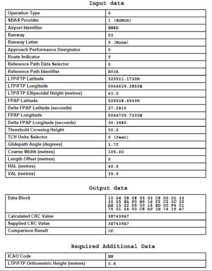
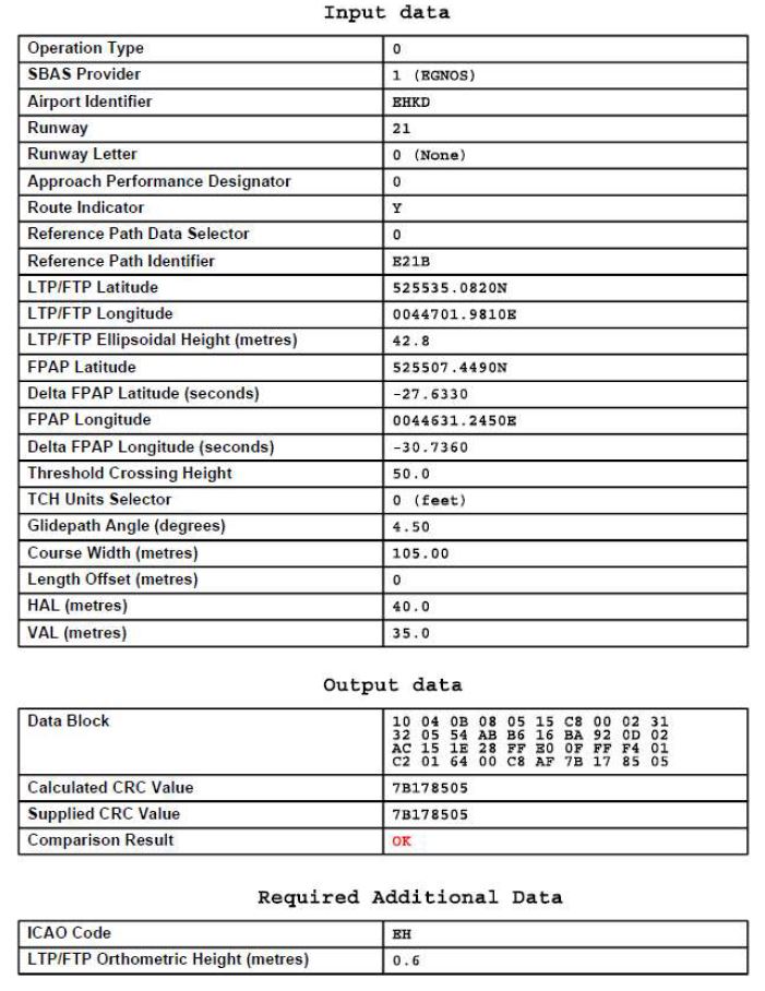
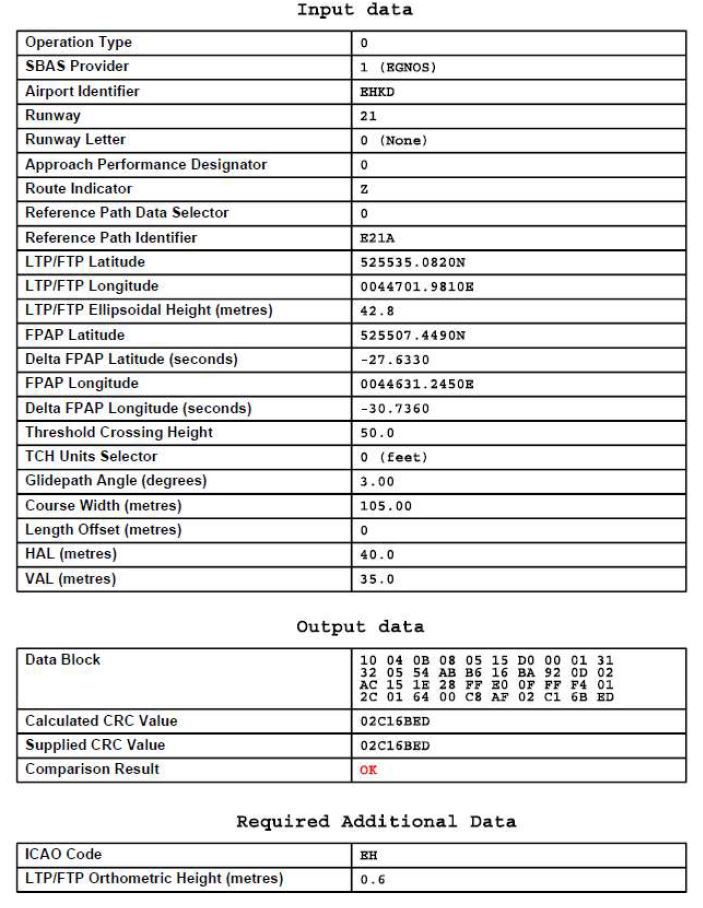
See EHKD AD 2.22 for FAS data block
|
NIL
Prior to engine start, pilots must request a start-up clearance to De Kooy Ground; a request for start-up shall include:
- callsign;
- position;
- type of aircraft;
- POB;
- ETD (in case of IFR clearance required).
The start-up clearance will include the runway in use and QNH.
- position;
- type of aircraft;
- POB;
- ETD (in case of IFR clearance required).
When required, ATC will issue an en-route clearance as soon as possible after taxi permission has been given.
An en-route clearance contains:
a. Clearance limit: airport of destination.
b. Departure instructions.
c. SSR code.
Example of an en-route clearance: "RNN345 is cleared to London, SPL 3000 FT, squawk 2123".
An en-route clearance contains:
b. Departure instructions.
c. SSR code.
Prior to ground/air-taxi, pilots shall request taxi permission from De Kooy Tower.
North Sea operations and HMR are described in ENR 2.2, ENR 3.4 and on En-route chart - ICAO (ENR 6).
MAX 250 KIAS below FL 100 unless otherwise instructed.
Transfer of control will be effected on the basis of current traffic situation and co-ordination between the units involved.
Traffic via the Schiphol TMAs will be transferred to Schiphol Departure.
Traffic via the Schiphol TMAs will be transferred to Schiphol Departure.
- If possible call Amsterdam ACC Supervisor on telephone number +31 (0)20 406 3999.
Note: use telephone connection to mitigate COM failure only. All telephone calls will be automatically recorded.
- If telephone connection is disconnected prematurely (before read-back), revert to general communication failure procedure (see ENR 1.3 paragraph "Communication Failure").
Additionally, for departing flights, the following communication failure procedure applies:
- If a clearance to climb or re-routing instructions have not been given, comply with the route and altitude limitations detailed in the allocated standard instrument departure procedure or the departure instructions provided at take-off until the last waypoint has been reached.
Note:
if a communication failure occurs during taxiing, aircraft shall wait until communication is re-established, light signals are issued from the tower or a follow-me car arrives.
Note: use telephone connection to mitigate COM failure only. All telephone calls will be automatically recorded.
- If telephone connection is disconnected prematurely (before read-back), revert to general communication failure procedure (see ENR 1.3 paragraph "Communication Failure").
- If a clearance to climb or re-routing instructions have not been given, comply with the route and altitude limitations detailed in the allocated standard instrument departure procedure or the departure instructions provided at take-off until the last waypoint has been reached.
- Transition altitude: 3000 FT AMSL.
- Turn radii based on a 18° bank angle and 125 KIAS.
- Procedures are designated for helicopters only.
-
RNAV:
the Netherlands encourages the use of RNAV routes stored in a pre-programmed navigation database on board of aircraft. Although there may be differences between the RNAV and conventional description of a route (vertically: turn altitudes and/or laterally: turn anticipation effects), the resulting flight paths are considered identical by ATC. Therefore, flying the route using the RNAV coding from the navigation database will not result in route violations.
Furthermore:
See charts SID RWY 03 CAT H.
|
ATRIX 3L
[ATRI3L] |
After departure climb to maintain 2000 FT AMSL. |
||||||||||
| Serial number | Path descriptor | WPT ident | Fly-over |
Course/Track
°MAG / (°T) |
Recom. navaid | Dist. (NM) | Turn | Altitude (FT / FL) |
Speed
(KIAS) |
VPA (°) / TCH (FT) |
NAV
specification |
| 001 | CF | KD400 | Y | 031 / (033.9) | DKY | - | - | - | - | - | RNAV 1 |
| 002 | CF | KD401 | Y | 053 / (056.4) | DKY | - | - | - | - | - | RNAV 1 |
| 003 | CF | KD403 | N | 277 / (280.5) | DKY | - | - | - | - | - | RNAV 1 |
| 004 | TF | ATRIX | N | 337 / (339.9) | - | 9.6 | - | - | - | - | RNAV 1 |
|
ATRIX 3N
[ATRI3N] |
After departure climb to maintain 2000 FT AMSL. |
||||||||||
| Serial number | Path descriptor | WPT ident | Fly-over |
Course/Track
°MAG / (°T) |
Recom. navaid | Dist. (NM) | Turn | Altitude (FT / FL) |
Speed
(KIAS) |
VPA (°) / TCH (FT) |
NAV
specification |
| 001 | CF | KD400 | Y | 031 / (033.9) | DKY | - | - | - | - | - | RNAV 1 |
| 002 | CF | KD401 | Y | 053 / (056.4) | DKY | - | - | - | - | - | RNAV 1 |
| 003 | CF | KD402 | N | 277 / (280.5) | DKY | - | - | - | - | - | RNAV 1 |
| 004 | TF | KD405 | N | 350 / (352.1) | - | 2.7 | - | - | - | - | RNAV 1 |
| 005 | TF | ATRIX | N | 325 / (327.9) | - | 7.7 | - | - | - | - | RNAV 1 |
|
GIKOV 3L
[GIKO3L] |
After departure climb to maintain 2000 FT AMSL. |
||||||||||
| Serial number | Path descriptor | WPT ident | Fly-over |
Course/Track
°MAG / (°T) |
Recom. navaid | Dist. (NM) | Turn | Altitude (FT / FL) |
Speed
(KIAS) |
VPA (°) / TCH (FT) |
NAV
specification |
| 001 | CF | KD400 | Y | 031 / (033.9) | DKY | - | - | - | - | - | RNAV 1 |
| 002 | CF | KD401 | Y | 053 / (056.4) | DKY | - | - | - | - | - | RNAV 1 |
| 003 | CF | KD404 | N | 277 / (280.5) | DKY | - | - | - | - | - | RNAV 1 |
| 004 | TF | GIKOV | N | 323 / (325.8) | - | 8.4 | - | - | - | - | RNAV 1 |
|
KOLAV 3L
[KOLA3L] |
After departure climb to maintain 2000 FT AMSL. |
||||||||||
| Serial number | Path descriptor | WPT ident | Fly-over |
Course/Track
°MAG / (°T) |
Recom. navaid | Dist. (NM) | Turn | Altitude (FT / FL) |
Speed
(KIAS) |
VPA (°) / TCH (FT) |
NAV
specification |
| 001 | CF | KD400 | Y | 031 / (033.9) | DKY | - | - | - | - | - | RNAV 1 |
| 002 | CF | KD401 | Y | 053 / (056.4) | DKY | - | - | - | - | - | RNAV 1 |
| 003 | CF | KOLAV | N | 277 / (280.5) | DKY | - | - | - | - | - | RNAV 1 |
|
LERGO 3L
[LERG3L] |
After departure climb to maintain 2000 FT AMSL. |
||||||||||
| Serial number | Path descriptor | WPT ident | Fly-over |
Course/Track
°MAG / (°T) |
Recom. navaid | Dist. (NM) | Turn | Altitude (FT / FL) |
Speed
(KIAS) |
VPA (°) / TCH (FT) |
NAV
specification |
| 001 | CF | KD400 | Y | 031 / (033.9) | DKY | - | - | - | - | - | RNAV 1 |
| 002 | CF | KD408 | Y | 081 / (056.4) | DKY | - | - | - | - | - | RNAV 1 |
| 003 | CF | LERGO | N | 262 / (264.9) | DKY | - | - | - | - | - | RNAV 1 |
|
NAKON 3L
[NAKO3L] |
After departure climb to maintain 2000 FT AMSL. |
||||||||||
| Serial number | Path descriptor | WPT ident | Fly-over |
Course/Track
°MAG / (°T) |
Recom. navaid | Dist. (NM) | Turn | Altitude (FT / FL) |
Speed
(KIAS) |
VPA (°) / TCH (FT) |
NAV
specification |
| 001 | CF | KD400 | Y | 031 / (033.9) | DKY | - | - | - | - | - | RNAV 1 |
| 002 | CF | KD408 | Y | 081 / (083.6) | DKY | - | - | - | - | - | RNAV 1 |
| 003 | CF | KD406 | N | 262 / (264.5) | DKY | - | - | - | - | - | RNAV 1 |
| 004 | TF | NAKON | N | 229 / (231.9) | - | 12.0 | - | - | - | - | RNAV 1 |
|
NEXAR 3L
[NEXA3L] |
After departure climb to maintain 2000 FT AMSL. |
||||||||||
| Serial number | Path descriptor | WPT ident | Fly-over |
Course/Track
°MAG / (°T) |
Recom. navaid | Dist. (NM) | Turn | Altitude (FT / FL) |
Speed
(KIAS) |
VPA (°) / TCH (FT) |
NAV
specification |
| 001 | CF | KD400 | Y | 031 / (033.9) | DKY | - | - | - | - | - | RNAV 1 |
| 002 | CF | KD408 | Y | 081 / (083.6) | DKY | - | - | - | - | - | RNAV 1 |
| 003 | CF | HDR | N | 262 / (280.5) | DKY | - | - | - | - | - | RNAV 1 |
| 004 | TF | NEXAR | N | 190 / (192.5) | - | 7.7 | - | - | - | - | RNAV 1 |
|
PEROR 3L
[PERO3L] |
After departure climb to maintain FL 050. |
||||||||||
| Serial number | Path descriptor | WPT ident | Fly-over |
Course/Track
°MAG / (°T) |
Recom. navaid | Dist. (NM) | Turn | Altitude (FT / FL) |
Speed
(KIAS) |
VPA (°) / TCH (FT) |
NAV
specification |
| 001 | CF | KD400 | Y | 031 / (033.9) | DKY | - | - | - | - | - | RNAV 1 |
| 002 | CF | KD408 | N | 081 / (083.6) | DKY | - | - | - | - | - | RNAV 1 |
| 003 | TF | PEROR | N | 047 / (049.6) | 9.5 | - | - | - | - | RNAV 1 | |
See charts SID RWY 21 CAT H.
|
ATRIX 3M
[ATRI3M] |
After departure climb to maintain 2000 FT AMSL. |
||||||||||
| Serial number | Path descriptor | WPT ident | Fly-over |
Course/Track
°MAG / (°T) |
Recom. navaid | Dist. (NM) | Turn | Altitude (FT / FL) |
Speed
(KIAS) |
VPA (°) / TCH (FT) |
NAV
specification |
| 001 | CA | - | - | 211 / (213.9) | - | - | R | +400 | - | - | RNAV 1 |
| 002 | CF | KD407 | N | 293 / (296.4) | DKY | - | - | - | - | - | RNAV 1 |
| 003 | TF | ATRIX | N | 347 / (349.2) | - | 12.8 | - | - | - | - | RNAV 1 |
|
ATRIX 4P
[ATRI4P] |
After departure climb to maintain 2000 FT AMSL. |
||||||||||
| Serial number | Path descriptor | WPT ident | Fly-over |
Course/Track
°MAG / (°T) |
Recom. navaid | Dist. (NM) | Turn | Altitude (FT / FL) |
Speed
(KIAS) |
VPA (°) / TCH (FT) |
NAV
specification |
| 001 | CA | - | - | 211 / (213.9) | - | - | L | +400 | - | - | RNAV 1 |
| 002 | DF | HDR | Y | - | - | - | - | - | - | - | RNAV 1 |
| 003 | CF | KD401 | Y | 053 / (055.6) | DKY | - | - | - | - | - | RNAV 1 |
| 004 | CF | KD403 | N | 277 / (279.6) | DKY | - | - | - | - | - | RNAV 1 |
| 005 | TF | ATRIX | N | 337 / (339.9) | - | 9.6 | - | - | - | - | RNAV 1 |
|
[ATRI4Q] |
After departure climb to maintain 2000 FT AMSL. |
||||||||||
| Serial number | Path descriptor | WPT ident | Fly-over |
Course/Track
°MAG / (°T) |
Recom. navaid | Dist. (NM) | Turn | Altitude (FT / FL) |
Speed
(KIAS) |
VPA (°) / TCH (FT) |
NAV
specification |
| 001 | CA | - | - | 211 / (213.9) | - | - | L | +400 | - | - | RNAV 1 |
| 002 | DF | HDR | Y | - | - | - | - | - | - | - | RNAV 1 |
| 003 | CF | KD401 | Y | 053 / (055.6) | DKY | - | - | - | - | - | RNAV 1 |
| 004 | CF | KD402 | N | 277 / (279.6) | DKY | - | - | - | - | - | RNAV 1 |
| 005 | TF | KD405 | N | 350 / (352.1) | - | 2.7 | - | - | - | - | RNAV 1 |
| 006 | TF | ATRIX | N | 325 / (327.9) | - | 7.7 | - | - | - | - | RNAV 1 |
|
GIKOV 3M
[GIKO3M] |
After departure climb to maintain 2000 FT AMSL. |
||||||||||
| Serial number | Path descriptor | WPT ident | Fly-over |
Course/Track
°MAG / (°T) |
Recom. navaid | Dist. (NM) | Turn | Altitude (FT / FL) |
Speed
(KIAS) |
VPA (°) / TCH (FT) |
NAV
specification |
| 001 | CA | - | - | 211 / (213.9) | - | - | R | +400 | - | - | RNAV 1 |
| 002 | CF | KD407 | N | 293 / (295.6) | DKY | - | - | - | - | - | RNAV 1 |
| 003 | TF | GIKOV | N | 330 / (332.8) | - | 12.2 | - | - | - | - | RNAV 1 |
|
GIKOV 4P
[GIKO4P] |
After departure climb to maintain 2000 FT AMSL. |
||||||||||
| Serial number | Path descriptor | WPT ident | Fly-over |
Course/Track
°MAG / (°T) |
Recom. navaid | Dist. (NM) | Turn | Altitude (FT / FL) |
Speed
(KIAS) |
VPA (°) / TCH (FT) |
NAV
specification |
| 001 | CA | - | - | 211 / (213.9) | - | - | L | +400 | - | - | RNAV 1 |
| 002 | DF | HDR | Y | - | - | - | - | - | - | - | RNAV 1 |
| 003 | CF | KD401 | Y | 053 / (055.6) | DKY | - | - | - | - | - | RNAV 1 |
| 004 | CF | KD404 | N | 277 / (279.6) | DKY | - | - | - | - | - | RNAV 1 |
| 005 | TF | GIKOV | N | 323 / (325.8) | - | 8.4 | - | - | - | - | RNAV 1 |
|
KOLAV 3M
[KOLA3M] |
After departure climb to maintain 2000 FT AMSL. |
||||||||||
| Serial number | Path descriptor | WPT ident | Fly-over |
Course/Track
°MAG / (°T) |
Recom. navaid | Dist. (NM) | Turn | Altitude (FT / FL) |
Speed
(KIAS) |
VPA (°) / TCH (FT) |
NAV
specification |
| 001 | CA | - | - | 211 / (213.9) | - | - | R | +400 | - | - | RNAV 1 |
| 002 | CF | KD407 | N | 293 / (295.6) | DKY | - | - | - | - | - | RNAV 1 |
| 003 | TF | KOLAV | N | 293 / (295.7) | - | 13.7 | - | - | - | - | RNAV 1 |
|
KOLAV 4P
[KOLA4P] |
After departure climb to maintain 2000 FT AMSL. |
||||||||||
| Serial number | Path descriptor | WPT ident | Fly-over |
Course/Track
°MAG / (°T) |
Recom. navaid | Dist. (NM) | Turn | Altitude (FT / FL) |
Speed
(KIAS) |
VPA (°) / TCH (FT) |
NAV
specification |
| 001 | CA | - | - | 211 / (213.9) | - | - | L | +400 | - | - | RNAV 1 |
| 002 | DF | HDR | Y | - | - | - | - | - | - | - | RNAV 1 |
| 003 | CF | KD401 | Y | 053 / (055.6) | DKY | - | - | - | - | - | RNAV 1 |
| 004 | CF | KOLAV | N | 277 / (279.6) | DKY | - | - | - | - | - | RNAV 1 |
|
LERGO 3M
[LERG3M] |
After departure climb to maintain 2000 FT AMSL. |
||||||||||
| Serial number | Path descriptor | WPT ident | Fly-over |
Course/Track
°MAG / (°T) |
Recom. navaid | Dist. (NM) | Turn | Altitude (FT / FL) |
Speed
(KIAS) |
VPA (°) / TCH (FT) |
NAV
specification |
| 001 | CA | - | - | 211 / (213.9) | - | - | R | +400 | - | - | RNAV 1 |
| 002 | CF | KD407 | N | 293 / (295.6) | DKY | - | - | - | - | - | RNAV 1 |
| 003 | TF | LERGO | N | 256 / (258.2) | - | 12.7 | - | - | - | - | RNAV 1 |
|
NAKON 3M
[NAKO3M] |
After departure climb to maintain 2000 FT AMSL. |
||||||||||
| Serial number | Path descriptor | WPT ident | Fly-over |
Course/Track
°MAG / (°T) |
Recom. navaid | Dist. (NM) | Turn | Altitude (FT / FL) |
Speed
(KIAS) |
VPA (°) / TCH (FT) |
NAV
specification |
| 001 | CA | - | - | 211 / (213.9) | - | - | R | +400 | - | - | RNAV 1 |
| 002 | CF | KD407 | N | 293 / 295.6) | DKY | - | - | - | - | - | RNAV 1 |
| 003 | TF | NAKON | N | 225 / (227.4) | - | 13.2 | - | - | - | - | RNAV 1 |
|
NEXAR 3M
[NEXA3M] |
After departure climb to maintain 2000 FT AMSL. |
||||||||||
| Serial number | Path descriptor | WPT ident | Fly-over |
Course/Track
°MAG / (°T) |
Recom. navaid | Dist. (NM) | Turn | Altitude (FT / FL) |
Speed
(KIAS) |
VPA (°) / TCH (FT) |
NAV
specification |
| 001 | CA | - | - | 211 / (213.9) | - | - | L | +400 | - | - | RNAV 1 |
| 002 | CF | NEXAR | N | 190 / (192.6) | DKY | - | - | - | - | - | RNAV 1 |
|
PEROR 4M
[PERO4M] |
After departure climb to maintain FL 050. |
||||||||||
| Serial number | Path descriptor | WPT ident | Fly-over |
Course/Track
°MAG / (°T) |
Recom. navaid | Dist. (NM) | Turn | Altitude (FT / FL) |
Speed
(KIAS) |
VPA (°) / TCH (FT) |
NAV
specification |
| 001 | CA | - | - | 211 / (213.9) | - | - | L | +400 | - | - | RNAV 1 |
| 002 | DF | HDR | Y | - | - | - | - | - | - | - | RNAV 1 |
| 003 | CF | PEROR | N | 049 / (051.3) | DKY | - | - | - | - | - | RNAV 1 |
MAX 250 KIAS below FL 100.
Inbound traffic will be transferred by Amsterdam ACC or MILATCC Schiphol to De Kooy Arrival (traffic via Schiphol will be transferred to Schiphol Approach).
Note:
an aircraft vectored to intercept final approach shall report to ATC when established on the final approach track (ICAO Doc 4444-ATM/501 (PANS-ATM) chapter 8.9.4.1).
During the initial approach radar service may be provided by Amsterdam ACC, MILATCC Schiphol, Schiphol APP or De Kooy Arrival.
The minimum initial approach altitude is 2000 FT AMSL. An IFR flight may be cleared to execute a visual approach provided that the pilot can maintain visual reference to the terrain and:
- the reported ceiling is at or above the approved initial approach level for the aircraft cleared; or
- the pilot reports at the initial approach level, or at any time during the instrument approach procedure, that the meteorological conditions are as such that with reasonable assurance a visual approach can be completed.
- the pilot reports at the initial approach level, or at any time during the instrument approach procedure, that the meteorological conditions are as such that with reasonable assurance a visual approach can be completed.
In case landing at EHKD with a helicopter is not possible and EHAM is filed as alternate aerodrome, there is a diversion route to EHAM RWY 22 (see EHAM chart IAC ILS or LOC RWY 22 CAT H).
De Kooy Approach will transfer this traffic to Schiphol Approach before NIDOP (TMA boundary).
When EHAM RWY 22 is not available, execute a circling procedure to EHAM RWY 27 unless otherwise instructed by ATC.
De Kooy Approach will transfer this traffic to Schiphol Approach before NIDOP (TMA boundary).
When EHAM RWY 22 is not available, execute a circling procedure to EHAM RWY 27 unless otherwise instructed by ATC.
ROUTE: NIDOP transition
RNAV: HDR / NIDOP / AM409 / AM410 / AM661 (FAF RWY 22).
RNAV: HDR / NIDOP / AM409 / AM410 / AM661 (FAF RWY 22).
- If possible call Amsterdam ACC Supervisor on telephone number +31 (0)20 406 3999.
Note: use telephone connection to mitigate COM failure only. All telephone calls will be automatically recorded.
- If telephone connection is disconnected prematurely (before read-back), revert to general communication failure procedure.
For the general procedures for IFR flights see ENR 1.3 paragraph "Communication Failure". Additionally, for arriving flights, the following communication failure procedures apply.
Note: use telephone connection to mitigate COM failure only. All telephone calls will be automatically recorded.
- If telephone connection is disconnected prematurely (before read-back), revert to general communication failure procedure.
- RNP APCH equipped proceed according to the current flight plan route to HDR.
- Maintain the last cleared and acknowledged flight level or altitude.
- After arrival over HDR, intercept the holding pattern.
- Commence descent to 2000 FT AMSL at or as near as possible to the ETO over HDR.
- After reaching 2000 FT AMSL leave HDR and carry out an RNP instrument approach procedure to the appropriate runway (see charts IAC RNP Z RWY 03 and IAC RNP Z RWY 21).
- RNP APCH equipped proceed according to the current flight plan route to the HDR.
- Maintain the last cleared and acknowledged flight level or altitude.
- After arrival over the clearance limit, intercept the associated holding pattern.
- Commence descent to 2000 FT AMSL at the EAT last received and acknowledged.
- When no EAT has been received and acknowledged, commence descent to 2000 FT AMSL at or as near as possible to the ETO over the clearance limit.
- After reaching 2000 FT AMSL leave the holding and carry out an RNP instrument approach procedure to the assigned runway (see charts IAC RNP Z RWY 03 and IAC RNP Z RWY 21).
Note:
for positions of KD waypoints see relevant instrument approach charts.
| Serial number | Path descriptor | WPT ident | Fly-over |
Course/Track
°MAG / (°T) |
Recom. navaid | Dist. (NM) | Turn | Altitude (FT / FL) |
Speed
(KIAS) |
VPA (°) / TCH (FT) |
NAV
specification |
| 001 | IF | NOFUD | - | - | - | - | - | + 2000 | - | - | - |
| 002 | TF | KOPFA | - | 031 / (033.8) | - | 3.0 | - | + 1200 | - | - | RNAV 1 |
| 003 | IF | FEWEX | - | - | - | - | - | + 2000 | - | - | - |
| 004 | TF | KOPFA | - | 101 / (103.8) | - | 3.0 | - | + 1200 | - | - | RNAV 1 |
| 005 | IF | TAFTU | - | - | - | - | - | + 2000 | - | - | - |
| 006 | TF | KOPFA | - | 321 / (323.8) | - | 3.0 | - | + 1200 | - | - | RNAV 1 |
| 007 | IF | KOPFA | - | - | - | - | - | + 1200 | - | - | - |
| 008 | TF | KD445 | - | 031 / (033.8) | - | 2.5 | - | + 1200 | - | - | RNP APCH |
| 009 | TF | THR03 | Y | 031 / (033.8) | - | 2.9 | - | - | - | -3.72/50 | RNP APCH |
| 010 | CA | - | - | 031 / (033.8) | - | - | - | + 1000 | - | - | RNP APCH |
| 011 | DF | KD444 | Y | - | - | - | R | - | - | - | RNP APCH |
| 012 | DF | HDR | - | - | - | - | R | @ 2000 | - | - | RNP APCH |
| Serial number | Path descriptor | WPT ident | Fly-over |
Course/Track
°MAG / (°T) |
Recom. navaid | Dist. (NM) | Turn | Altitude (FT / FL) |
Speed
(KIAS) |
VPA (°) / TCH (FT) |
NAV
specification |
| 001 | IF | NIXCO | - | - | - | - | - | + 2000 | - | - | - |
| 002 | TF | EDFOS | - | 070 / (071.9) | - | 3.0 | - | - | - | - | RNAV 1 |
| 003 | IF | HDR | - | - | - | - | - | + 2000 | - | - | - |
| 004 | TF | KD440 | - | 128 / 130.1) | - | 4.6 | - | - | - | - | RNAV 1 |
| 005 | TF | ASTUW | - | 180 / (182.7) | - | 5.0 | - | + 2000 | - | - | RNAV 1 |
| 006 | TF | KD441 | - | 258 / (260.4) | - | 2.9 | - | + 2000 | - | - | RNAV 1 |
| 007 | TF | EDFOS | - | 278 / (280.7) | - | 2.0 | - | + 2000 | - | - | RNAV 1 |
| 008 | IF | EDFOS | - | - | - | - | - | + 2000 | - | - | - |
| 009 | TF | KD442 | - | 008 / (010.6) | - | 3.0 | - | + 2000 | - | - | RNAV 1 |
| 010 | TF | HDR | Y | 008 / (010.6) | - | 5.2 | - | - | - | -3.00/50 | RNP APCH |
| 011 | CA | - | - | 008 / (010.6) | - | - | - | + 1000 | - | - | RNP APCH |
| 012 | DF | KD444 | Y | - | - | - | R | - | - | - | RNP APCH |
| 013 | DF | HDR | - | - | - | - | R | @ 2000 | - | - | RNP APCH |
| Serial number | Path descriptor | WPT ident | Fly-over |
Course/Track
°MAG / (°T) |
Recom. navaid | Dist. (NM) | Turn | Altitude (FT / FL) |
Speed
(KIAS) |
VPA (°) / TCH (FT) |
NAV
specification |
| 001 | IF | LOCFU | - | - | - | - | - | + 2000 | - | - | - |
| 002 | TF | KD454 | - | 121 / (123.8) | - | 5.0 | - | + 1500 | - | - | RNAV 1 |
| 003 | TF | HOXZA | - | 121 / (123.9) | - | 2.0 | - | + 1200 | - | - | RNAV 1 |
| 004 | IF | YOJUP | - | - | - | - | - | + 2000 | - | - | - |
| 005 | TF | HOXZA | - | 302 / (304.1) | - | 3.0 | - | + 1200 | - | - | RNAV 1 |
| 006 | IF | GOHEM | - | - | - | - | - | + 2000 | - | - | - |
| 007 | TF | HOXZA | - | 212 / (214.0) | - | 3.0 | - | + 1200 | - | - | RNAV 1 |
| 008 | IF | HOXZA | - | - | - | - | - | + 1200 | - | - | - |
| 009 | TF | KD455 | - | 212 / (214.0) | - | 2.8 | - | + 1200 | - | - | RNP APCH |
| 010 | TF | THR21 | Y | 212 / (214.0) | - | 2.4 | - | - | - | -4.50/50 | RNP APCH |
| 011 | CA | - | - | 212 / (214.0) | - | - | - | + 500 | - | - | RNP APCH |
| 012 | DF | KD453 | Y | - | - | - | L | - | - | - | RNP APCH |
| 013 | DF | HDR | - | - | - | - | R | @ 2000 | - | - | RNP APCH |
| Serial number | Path descriptor | WPT ident | Fly-over |
Course/Track
°MAG / (°T) |
Recom. navaid | Dist. (NM) | Turn | Altitude (FT / FL) |
Speed
(KIAS) |
VPA (°) / TCH (FT) |
NAV
specification |
| 001 | IF | PUFLA | - | - | - | - | - | + 2000 | - | - | - |
| 002 | TF | KD451 | - | 121 / (123.9) | - | 4.5 | - | + 2000 | - | - | RNAV 1 |
| 003 | TF | ZOJIK | - | 121 / (123.9) | - | 3.0 | - | + 1700 | - | - | RNAV 1 |
| 004 | IF | HDR | - | - | - | - | - | + 2000 | - | - | - |
| 005 | TF | YOJUP | - | 055 / (057.9) | - | 7.1 | - | - | - | - | RNAV 1 |
| 006 | TF | JOPFI | - | 032 / (034.0) | - | 3.0 | - | + 2000 | - | - | RNAV 1 |
| 007 | TF | ZOJIK | - | 302 / (304.1) | - | 3.0 | - | + 1700 | - | - | RNAV 1 |
| 008 | IF | FAFLO | - | - | - | - | - | + 2000 | - | - | - |
| 009 | TF | ZOJIK | - | 212 / (214.1) | - | 3.0 | - | + 1700 | - | - | RNAV 1 |
| 010 | IF | ZOJIK | - | - | - | - | - | + 1700 | - | - | - |
| 011 | TF | KD452 | - | 212 / (214.0) | - | 3.0 | - | + 1700 | - | - | RNP APCH |
| 012 | TF | THR21 | Y | 212 / (214.0) | - | 5.2 | - | - | - | -3.00/50 | RNP APCH |
| 012 | CA | - | - | 212 / (214.0) | - | - | - | + 500 | - | - | RNP APCH |
| 014 | DF | KD453 | Y | - | - | - | L | - | - | - | RNP APCH |
| 015 | DF | HDR | - | - | - | - | R | @ 2000 | -120 | - | RNP APCH |
During periods of low visibility the overall ATC capacity could be reduced. To guarantee aircraft safety and optimal use of ATC capacity, De Kooy uses low visibility procedures.
| Phase | Conditions | Procedure |
| A | RVR <= 1500 M and/or ceiling <= 300 FT | All WIP on airside will be terminated.
Separation between landing aircraft will be increased to 8 NM. No opposite runway take-off and landing. |
| B | RVR < 550 M | Departures only.
No simultaneous ground movements. |
| C | RVR < 300 M | The airport is below operational minima for arriving and departing aircraft. |
Note:
visual procedures see chart VAC - VFR procedures.
VFR traffic crossing the CTR shall be carried out via the VFR reporting points (see visual approach chart) at 1500 FT AMSL, unless
otherwise instructed or approved by ATC.
otherwise instructed or approved by ATC.
- Contact De Kooy TWR 2 minutes before reaching the CTR boundary for permission to enter the CTR.
- Unless otherwise instructed, enter the CTR via designated reporting points (see visual approach chart) at 1500 FT AMSL and maintain.
- Descent to circuit altitude according the joining procedure which will be instructed by ATC:
- VFR arrivals: ATC discretion only, when EHR8 (partly) inactive:
- RWY 03: righthand circuit at 1000 FT AMSL.
- RWY 21: lefthand circuit at 1000 FT AMSL.
- RWY 21: lefthand circuit at 1000 FT AMSL.
In case of excessive wind and upon request of the pilot, helicopters are allowed to depart/approach into the wind from/to mentioned helipads with prescribed circuit directions (only for (special)VFR departures/arrivals or visual landings). If it is the pilots intention to continue IFR after departure, contact as soon as practicable De Kooy Arrival (in accordance with the tower controller) to follow a SID.
- Select transponder code 7600.
- If possible call Amsterdam ACC Supervisor on telephone number +31 (0)20 406 3999.
Note: use telephone connection to mitigate COM failure only. All telephone calls will be automatically recorded.
- If telephone connection is disconnected prematurely (before read-back):
1. Climb/descent to 1500 FT AMSL according to the last known local QNH.
2. Join a regular VFR arrival route at 1500 FT AMSL.
3. Proceed to the west side of the runway at 1500 FT AMSL (via overhead when required to cross the centre line).
4. When clear of centre line descend 500 FT AAL and proceed along the west side of the runway in use (direction upwind). If possible, fly "waggling wings"’ and flash landing lights.
5. When passing upwind threshold turn downwind, maintain 500 FT AAL.
6. When green light signal issued on downwind, continue the approach. In case of a red light signal, start orbiting on downwind at 500 FT AAL and wait for a green light signal.
7. On final, landing clearance will be issued by a green light signal.
8. After landing, vacate the runway and follow taxi instructions as issued by light signals.
9. In case of any additional emergency remain on the runway.
Note:
if a communication failure occurs during taxiing, aircraft shall wait until communication is re-established, light signals are issued from the tower or a follow-me car arrives.
- If possible call Amsterdam ACC Supervisor on telephone number +31 (0)20 406 3999.
Note: use telephone connection to mitigate COM failure only. All telephone calls will be automatically recorded.
- If telephone connection is disconnected prematurely (before read-back):
1. Climb/descent to 1500 FT AMSL according to the last known local QNH.
2. Join a regular VFR arrival route at 1500 FT AMSL.
3. Proceed to the west side of the runway at 1500 FT AMSL (via overhead when required to cross the centre line).
4. When clear of centre line descend 500 FT AAL and proceed along the west side of the runway in use (direction upwind). If possible, fly "waggling wings"’ and flash landing lights.
5. When passing upwind threshold turn downwind, maintain 500 FT AAL.
6. When green light signal issued on downwind, continue the approach. In case of a red light signal, start orbiting on downwind at 500 FT AAL and wait for a green light signal.
7. On final, landing clearance will be issued by a green light signal.
8. After landing, vacate the runway and follow taxi instructions as issued by light signals.
9. In case of any additional emergency remain on the runway.
1. Intensive training operations with helicopters and light aircraft.
2. Light aircraft and model flying daily outside operational hours.
3. Glider site Noordkop is located 8 NM east of ARP, just outside the CTR.
4. UAS activities in the port of Den Helder MON-FRI 0600-1430 (MON-FRI 0500-1330). For more information, contact ATC De Kooy.
5. UAS activities on the military base at the southeast point of Texel.
6. Overflying the gas plant (0.5 NM east of ARP) below 1000 FT AMSL is prohibited.
2. Light aircraft and model flying daily outside operational hours.
3. Glider site Noordkop is located 8 NM east of ARP, just outside the CTR.
4. UAS activities in the port of Den Helder MON-FRI 0600-1430 (MON-FRI 0500-1330). For more information, contact ATC De Kooy.
5. UAS activities on the military base at the southeast point of Texel.
6. Overflying the gas plant (0.5 NM east of ARP) below 1000 FT AMSL is prohibited.
EHR8 is active MON-THU 0700-2300 (MON-THU 0600-2200), FRI 0700-1600 (FRI 0600-1500), or activated by NOTAM: see ENR 5.1.
This area is partly overlapping the CTR, the east boundary of EHR8 is situated east of the dunes.
This area is partly overlapping the CTR, the east boundary of EHR8 is situated east of the dunes.
Civil traffic requesting prior permission contact Den Helder Airport:
A standard request form can be obtained through the above mentioned email address or can be found on the webpage of Den Helder Airport https://denhelderairport.nl/eng/information-for-pilots/. When intending a full stop landing at De Kooy, please also include refuel, accommodation or other requirements.
Note:
only fully completed requests will be considered.
| Email: | [email protected] |
After landing RWY 03, passing the runway end lights at taxiing speed is allowed. Beyond the runway end lights the pavement is classified as taxiway and equipped with alternating green/yellow centre line lights up to exit D1.
Take-off RWY 21 is allowed from the runway extremity.
Take-off RWY 21 is allowed from the runway extremity.
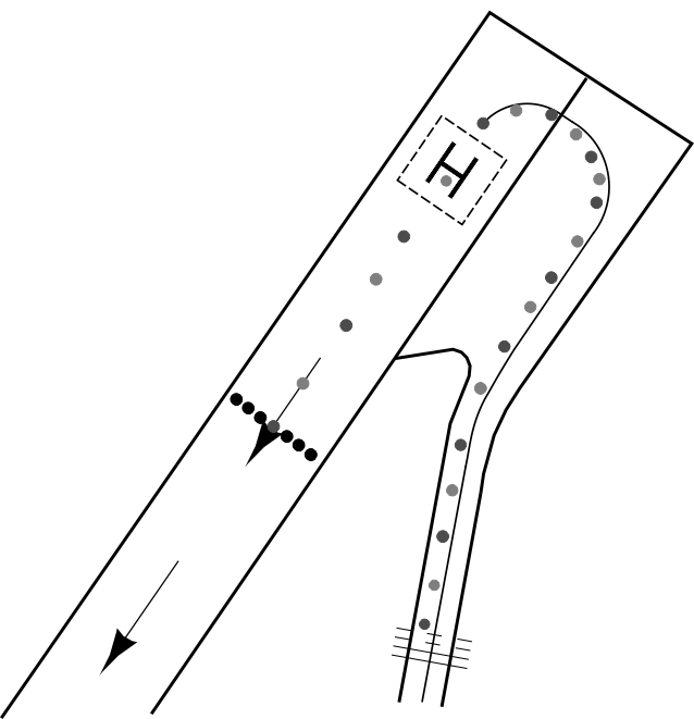
The datum line from which the reduced runway declared distances for take-off should be determined is defined by the intersection of the downwind edge of the specific taxiway with the runway edge.
The loss of runway length due to alignment of the aircraft prior to take-off should be taken into account by the operators for the calculation of the aircraft’s take-off mass (ICAO Annex 6, Part 1, paragraph 5.2.8).
The loss of runway length due to alignment of the aircraft prior to take-off should be taken into account by the operators for the calculation of the aircraft’s take-off mass (ICAO Annex 6, Part 1, paragraph 5.2.8).
| Ground Handling DHA | |
| Post: | Ground Handling DHA
Luchthavenweg 10b 1786 PP Den Helder The Netherlands |
| TEL: | +31 (0)223 677 566 |
| Email: | [email protected] |
| Note: | Contact company/handling on 131.505. |

NIL