EHTW AD 2.1 AERODROME LOCATION INDICATOR AND NAME
EHTW - ENSCHEDE/TWENTE
EHTW AD 2.2 AERODROME GEOGRAPHICAL AND ADMINISTRATIVE DATA
1
ARP coordinates and site at AD
521633N 0065321E
Middle of runway.
2
Direction and distance from (city)
2 NM N of Enschede.
3
Elevation / reference temperature
ELEV: 115 FT AMSL / T: 21.3 °C
4
Geoid undulation at AD ELEV PSN
143 FT
5
MAG VAR / annual change
3° E (2025) / 0.2° E
6
AD operator, address, telephone, telefax, email address, AFS, URL
TWENTE AIRPORT
VLIEGVELDSTRAAT 100 
7524 PK ENSCHEDE
THE NETHERLANDS

TEL: +31 (0)6 21 342 953 (TWR)
TEL: +31 (0)6 45 484 719 (AD OFFICE)
email: [email protected]
URL: https://www.twente-airport.nl

7
Types of traffic permitted (IFR/VFR)
VFR
8
Remarks
- Aerodrome available for national and international civil air traffic with all types of aircraft.
- When an aircraft of ICAO approach category D operates to or from Twente Airport, the flight crew must have read the local briefing and completed the mandatory test prior to the flight(s). See EHTW AD 2.23.

EHTW AD 2.3 OPERATIONAL HOURS
1
AD operator
MON-FRI 0800-1600 (MON-FRI 0600-1800) during UDP
SAT 0800-1600 (SAT 0700-1800) during UDP
SUN HOL 0900-1600 (SUN HOL 0800-1800) during UDP

2
Customs and immigration
MON-FRI 0800-1600 (MON-FRI 0600-1800) during UDP
SAT 0800-1600 (SAT 0700-1800) during UDP
SUN HOL 0900-1600 (SUN HOL 0800-1800) during UDP

3
Health and sanitation
NIL
4
AIS briefing office
H24
5
ATS reporting office (ARO)
H24
6
MET briefing office
NIL
7
ATS
NIL
8
Fuelling
MON-FRI 0800-1600 (MON-FRI 0600-1800) during UDP
SAT 0800-1600 (SAT 0700-1800) during UDP
SUN HOL 0900-1600 (SUN HOL 0800-1800) during UDP

9
Handling
MON-FRI 0800-1600 (MON-FRI 0600-1800) during UDP
SAT 0800-1600 (SAT 0700-1800) during UDP
SUN HOL 0900-1600 (SUN HOL 0800-1800) during UDP

10
Security
MON-FRI 0800-1600 (MON-FRI 0600-1800) during UDP
SAT 0800-1600 (SAT 0700-1800) during UDP
SUN HOL 0900-1600 (SUN HOL 0800-1800) during UDP

11
De-icing
NIL
12
Remarks
AD operator
  • Home based ACFT MNM 3 HR PPR within AD OPR HR. All other ACFT MNM 24 HR PPR.
Customs and immigration
  • 4 HR prior notice.

MET briefing office
  • Self-briefing during AD OPR HR.
Fuelling
  • O/R.
Handling
  • O/R.
Security
  • O/R.
EHTW AD 2.4 HANDLING SERVICES AND FACILITIES
1
Cargo-handling facilities
NIL
2
Fuel / oil types
Fuel: JET A-1
Oil: NIL
3
Fuelling facilities/capacity
JET A-1 O/R
Mobile charging facilities AVBL for Pipistrel Velis Electro.

4
De-icing facilities
NIL
5
Hangar space for visiting aircraft
AVBL, O/R.
6
Repair facilities for visiting aircraft
AVBL
7
Remarks
GPU AVBL (28/115V).
EHTW AD 2.5 PASSENGER FACILITIES
1
Hotels
In Enschede, Hengelo and Oldenzaal.
2
Restaurants
In Enschede, Hengelo and Oldenzaal.
3
Transportation
AVBL O/R.
4
Medical facilities
Hospitals in Enschede and Hengelo.
5
Bank and post office
Bank: In Enschede, Hengelo and Oldenzaal.
Post: In Enschede, Hengelo and Oldenzaal.
6
Tourist office
In Enschede, Hengelo and Oldenzaal.
7
Remarks
NIL
EHTW AD 2.6 RESCUE AND FIREFIGHTING SERVICES
1
AD category for firefighting
CAT OTHER
2
Rescue equipment
NIL
3
Capability for removal of disabled aircraft
Hoist and lift capacity AVBL.
4
Remarks
AD category for fire fighting
  • Required CAT O/R, 24 HR PN.
  • 2 crash-tenders and 1 fire truck.
EHTW AD 2.7 RUNWAY SURFACE CONDITION ASSESSMENT AND REPORTING, AND SNOW PLAN
1
Types of clearing equipment
1 snow sweeper, 1 snow plough.
2
Clearance priorities
RWY, TWY, intersection, apron.
3
Use of material for movement area surface treatment
NIL
4
Specially prepared winter runways
NIL
5
Remarks
Caution advised in winter during possible icing conditions on RWY, TWY and apron. Clearing of surfaces at discretion of AD operator.
EHTW AD 2.8 APRONS, TAXIWAYS AND CHECK LOCATIONS/POSITIONS DATA
1
Apron designation, surface and strength
Designation
Stand
Surface
Strength
A-apron
  Concrete
PCR 686 R/B/W/T
C-apron
  Concrete
PCR 686 R/B/W/T
D-apron
  Concrete
PCR 686 R/B/W/T
2
Taxiway designation, width, surface and strength
Designation of TWY
Width
Surface
Strength
TWY N3
23.0 M
Asphalt
PCR 489/F/A/W/T
TWY N4
22.5 M
Asphalt
PCR 686/R/B/W/T
3
Altimeter checkpoint location and elevation
Apron; 115 FT AMSL
4
VOR checkpoints
NIL
5
INS checkpoints
NIL
6
Remarks
Apron designation, surface and strength
C-apron AVBL for ACFT CAT A, B and C.
Within UDP:
- ACFT stand C1 to be used by ACFT CAT C (MAX wheelbase 18 M);
- ACFT stands C2 to C5 to be used by ACFT CAT A and B.

EHTW AD 2.9 SURFACE MOVEMENT GUIDANCE AND CONTROL SYSTEM AND MARKINGS
1
Use of aircraft stand ID signs, TWY guide lines and visual docking/parking guidance system at aircraft stands
TWY guide lines.
Follow-me car and marshaller assistance AVBL O/R.

2
RWY and TWY markings and LGT
RWY markings
- RWY 05: THR, transverse stripe, arrows, designation, aiming point, CL, turn pad marking.
- RWY 23: THR, transverse stripe, arrows, designation, aiming point, CL, turn pad marking.


RWY LGT
- RWY 05: THR, edge, RWY end.
- RWY 23: THR, edge, RWY end.

TWY markings
- CL
- RWY HLDG positions pattern A.

TWY LGT
- RWY exit N3 blue edge lights
- TWY N3 blue retroreflective edge markers.
3
Stop bars
NIL
4
Remarks

NIL
EHTW AD 2.10 AERODROME OBSTACLES
For obstacle information in the take-off areas, contact the aerodrome operator.
Area 2
OBST ID / designation
OBST type
OBST position
ELEV/HGT (FT)
Markings /
type, colour LGT

Remarks
1
2
3
4
5
6
NIL
Area 3
OBST ID / designation
OBST type
OBST position
ELEV/HGT (FT)
Markings /
type, colour LGT

Remarks
1
2
3
4
5
6
NIL
EHTW AD 2.11 METEOROLOGICAL INFORMATION PROVIDED
Available at the aerodrome.
1
Associated MET office
NIL
2
Hours of service
MET office outside hours

Hours of service
NIL


MET office outside hours
NIL

3
Office responsible for TAF preparation
Period of validity


NIL
4
Trend forecast
Interval of issuance

NIL
5
Briefing/consultation provided
Available at the aerodrome office.
6
Flight documentation
Language(s) used

NIL
7
Charts and other information available for briefing or consultation
NIL
8
Supplementary equipment available for providing information
NIL
9
ATS units provided with information
NIL
10
Additional information (limitation of service, etc.)
NIL
EHTW AD 2.12 RUNWAY PHYSICAL CHARACTERISTICS
RWY designation
True BRG
Dimensions of RWY (M)
Strength (PCN) and surface of RWY and SWY
THR coordinates
RWY end coordinates
THR GUND

THR ELEV and highest ELEV of TDZ of precision APCH RWY
1
2
3
4
5
6
05
055.00°
2406 x 45
RWY: PCR 511/F/A/W/T
Asphalt
SWY: NIL
THR:
521610.66N 0065228.79E

RWY end: NIL
THR GUND: 143 FT
THR: 99 FT
TDZ: NIL
23
235.00°
2406 x 45
RWY: PCR 511/F/A/W/T
Asphalt
SWY: NIL
THR:
521655.32N 0065412.75E

RWY end: NIL
THR GUND: 143 FT
THR: 114 FT
TDZ: NIL
RWY designation
Slope of RWY-SWY
SWY dimensions (M)
CWY dimensions (M)
Strip dimensions (M)
RESA dimensions (M)
Location and description of arresting system
OFZ
1
7
8
9
10
11
12
13
05
0%
NIL
NIL
2526 x 300
240 x 150
NIL
NIL
23
0%
NIL
NIL
2526 x 300
240 x 150
NIL
NIL
RWY designation
Remarks
1
14
05
NIL
23
NIL
EHTW AD 2.13 DECLARED DISTANCES
RWY designator
TORA
(M)

TODA
(M)

ASDA
(M)

LDA
(M)

Remarks
1
2
3
4
5
6
05
2406
2406
2406
2406
NIL
05
2322
2322
2322
NIL
Take-off from intersection with TWY: N4
Only permitted after approval by the aerodrome operator. Turbine engined aircraft shall use full runway length.
05
1481
1481
1481
NIL
Take-off from intersection with TWY: N3
Only permitted after approval by the aerodrome operator. Turbine engined aircraft shall use full runway length.
23
2406
2406
2406
2406
NIL
23
959
959
959
NIL
Take-off from intersection with TWY: N3
Only permitted after approval by the aerodrome operator. Turbine engined aircraft shall use full runway length.
EHTW AD 2.14 APPROACH AND RUNWAY LIGHTING
RWY
designator

APCH LGT
type
length
INTST

THR LGT
colour
WBAR

VASIS
location/slope
MEHT

TDZ LGT
length

RWY CL LGT
length
spacing
colour
INTST

1
2
3
4
5
6
05
SALS
450 M
LIH
G
NIL
PAPI
Left side/3.0°
73 FT
NIL
NIL
23
SALS
450 M
LIH
G
NIL
PAPI
Left side/3.0°
73 FT
NIL
NIL
RWY
designator

RWY edge LGT
length
spacing
colour
INTST

RWY end LGT
colour
WBAR

SWY LGT
length
colour

Remarks
1
7
8
9
10
05
2406 M
60 M
W
LIH
R
NIL
NIL
RWY edge LGT
Colour: 1500 M white, 600 M yellow, 300 M red.

23
2406 M
60 M
W
LIH
R
NIL
NIL
RWY edge LGT
Colour: 1500 M white, 600 M yellow, 300 M red.

EHTW AD 2.15 OTHER LIGHTING, SECONDARY POWER SUPPLY
1
ABN/IBN location, characteristics and hours of operation
NIL
2
LDI location and LGT
Anemometer location and LGT

LDI: NIL
Anemometer: NIL
3
TWY edge and centre line lighting
See EHTW AD 2.9.
4
Secondary power supply
Switchover time

AVBL
15 seconds.

5
Remarks
NIL
EHTW AD 2.16 HELICOPTER LANDING AREA
1
Coordinates TLOF or THR of FATO
Geoid undulation

NIL
2
TLOF and/or FATO elevation
NIL
3
TLOF and FATO area dimensions, surface, strength, marking
NIL
4
True BRG of FATO
NIL
5
Declared distances available
NIL
6
APCH and FATO lighting
NIL
7
Remarks
NIL
EHTW AD 2.17 AIR TRAFFIC SERVICES AIRSPACE
Designation and lateral limits
Vertical limits
Airspace classification
ATS unit
call sign
language(s)

Transition altitude
Hours of applicability
Remarks
1
2
3
4
5
6
7
NIL
NIL
G
NIL
NIL
NIL
NIL
EHTW AD 2.18 AIR TRAFFIC SERVICES COMMUNICATION FACILITIES
Service
designation

Call sign
Channel(s)
SATVOICE NR
Logon address
Hours of operation
Remarks
1
2
3
4
5
6
7
INFO
Twente Radio
119.955
NIL
NIL
MON-FRI 0800-1600 (MON-FRI 0600-1800) during UDP
SAT 0800-1600 (SAT 0700-1800) during UDP
SUN HOL 0900-1600 (SUN HOL 0800-1800) during UDP

NIL
EHTW AD 2.19 RADIO NAVIGATION AND LANDING AIDS
Type of aid
MAG VAR
Supported OPS
ILS CAT
GBAS facility
(VOR/ILS/MLS declination)

ID
Frequency
CH
Service provider
Reference path ID

Hours of operation
Position of transmitting antenna
DME: ELEV
transmitting antenna
GBAS: ELEV
ellipsoid
height
reference point
SBAS: ellipsoid
height LTP/FTP

GBAS
reference
point
service
volume
radius

Remarks
1
2
3
4
5
6
7
8
GPS
NIL
L1
1575.42 MHz
H24
NIL
NIL
NIL
NIL
EGNOS
NIL
L1
1575.42 MHz
H24
NIL
NIL
NIL
NIL
EHTW AD 2.20 LOCAL AERODROME REGULATIONS
Aircraft to and from Twente Airport need prior permission from the airport operator (PPR 24 HR).
EHTW AD 2.21 NOISE ABATEMENT PROCEDURES
To avoid the build-up areas of Enschede and Oldenzaal, noise abatement procedures have been introduced for arrivals and departures (see EHTW AD 2.22). Intersection departures are not allowed for turbine-engined aircraft. They shall use full runway length.
EHTW AD 2.22 FLIGHT PROCEDURES

1 VFR FLIGHT PROCEDURES AND REGULATIONS

1.1 General

The ATZ/RMZ Twente is active during operational hours of the aerodrome within UDP. For the lateral and vertical limits of ATZ/RMZ Twente see the chart VAC - VFR procedures. Traffic not in- or outbound Twente Airport is strongly advised not to enter the ATZ.
 
Contact Twente Radio before entering the ATZ Twente or before departing Twente Airport and state your intentions. Twente Radio responds with aerodrome information. Twente Radio is strictly informative.
 
Two circuit areas have been established at Twente Airport.
  • Circuit area north of the runway is intended for local flying clubs, visiting aircraft of ICAO approach category A, or aircraft operated in accordance with EASA Part NCO.
  • Circuit area south of the runway is intended for aircraft types of ICAO aircraft approach category B and C, or aircraft operated in accordance with EASA Part CAT or NCC.

Note:  both circuit areas may not be overflown below an altitude of 2200 FT AMSL (2085 FT AAL).

For circuit area north the standard circuit procedure is applicable (see ENR 1.2 paragraph 8). The circuit altitude is 1000 FT AMSL (885 FT AAL). The visual traffic circuit must be carried out within the lateral limits of the circuit area appropriate to the runway in use.


For circuit area south non-standard circuit procedures are applicable. The circuit altitude is 1700 FT AMSL (1585 FT AAL). The visual traffic circuit must be carried out by reference to the prescribed tracks appropriate to the runway in use.

Note:  for co-ordinates of waypoints see ENR 4.4.

The visual departure procedures are specified in paragraph 1.2. Traffic in circuit area north leaves the circuit by one of the exits indicated on the circuit area at the chart VAC - VFR procedures. Traffic in circuit area south leaves the circuit via BEKVU.

 
The visual approach procedures are specified in paragraph 1.3. Noise abatement has been included in the procedures. Therefore pilots shall adhere to the VFR traffic circuit, arrival and departure procedures as depicted. Built-up areas shall be avoided as much as possible.

1.2 Visual departure procedures

1.2.1 Category B and C aircraft on a Z flight plan, or aircraft operated in accordance with EASA Part CAT or NCC

Note:  for the visual approach chart, waypoints and traffic circuits see VAC.
Twente Radio will relay the IFR en-route clearance of MILATCC Schiphol to the pilot before departure. For noise abatement reasons the VFR departure procedure shall be followed to at least BEKVU.
1.2.1.1 RWY 05
  • Climb on runway track.
  • At 600 FT AMSL (485 FT AAL) but not before end of RWY 05, turn right to BEKVU with MAX 160 KIAS and climb to 3000 FT AMSL.
  • At BEKVU proceed to RKN DME and remain VMC below FL 065.
  • Contact Dutch MIL and proceed in accordance with IFR clearance.
1.2.1.2 RWY 23
  • Climb on runway track to 3000 FT AMSL.
  • Proceed BEKVU - RKN DME and remain VMC below FL 065 in the Nieuw Milligen TMA C.
  • Contact Dutch MIL and proceed in accordance with IFR clearance.

1.2.2 Category A aircraft or aircraft operated in accordance with EASA Part NCO

Note:  for the visual procedures, waypoints and traffic circuits see chart VAC - VFR procedures.
  • Intersection departures are permitted for piston-engine aircraft after approval from the AD operator.
  • After take-off climb to 1000 FT AMSL (885 FT AAL) and leave the circuit area as depicted on chart VAC - VFR procedures.

1.2.3 Communication failure during departure

  • In VMC below FL 065: return to BEKVU and land via BEKVU arrival on runway in use.
  • In IMC and above FL 065: follow route according to route clearance and flight plan as prescribed by ICAO (Doc 4444 PANS ATM).

1.3 Visual approach procedures

1.3.1 Category B and C aircraft on an IFR/VFR flight plan, or aircraft operated in accordance with EASA Part CAT or NCC

Note:  for the visual procedure, waypoints and traffic circuits see VAC.
1.3.1.1 RWY 05
  • Proceed to BEKVU at 2000 FT AMSL (1885 FT AAL) in VMC, cancel IFR before arriving at BEKVU and continue VFR.
  • Descend to 1700 FT AMSL (1585 FT AAL) when established on the nominal track between BEKVU and TUXAR.
  • Intercept runway track and initiate final descent in accordance with the PAPI from 1700 FT AMSL (1585 FT AAL).
1.3.1.2 Missed approach RWY 05
  • Remain VMC, maintain runway track and climb to 1700 FT AMSL.
  • At the end of RWY 05 (but not below 600 FT AMSL) turn right to BEKVU with MAX 160 KIAS.
  • Contact Dutch MIL.
  • At BEKVU 1700 FT AMSL (MAX 185 KIAS), continue on heading 264 to carry out procedure turn inbound BEKVU 2000 FT AMSL and execute the approach procedure again. If required, Dutch MIL will provide radar vectors.
1.3.1.3 RWY 23
  • Proceed to BEKVU at 2000 FT AMSL (1885 FT AAL) in VMC, cancel IFR before BEKVU and continue VFR.
  • Descend to 1700 FT AMSL (1585 FT AAL) when established on the nominal track between BEKVU and TUXAR.
  • Proceed TUXAR - LONLU - LUTET at 1700 FT AMSL (1585 FT AAL) with MAX 160 KIAS.
  • At LUTET start turn to base leg and descend to final.
  • Intercept runway axis and PAPI slope at approximately 1200 FT AMSL.
1.3.1.4 Missed approach RWY 23
  • Remain VMC, maintain runway track and climb to 1700 FT AMSL.
  • Contact Dutch MIL.
  • At BEKVU 1700 FT AMSL (MAX 185 KIAS), continue on heading 264 to carry out procedure turn inbound BEKVU 2000 FT AMSL and execute the approach procedure again. If required, Dutch MIL will provide radar vectors.

1.3.2 Category A aircraft or aircraft operated in accordance with EASA Part NCO

Note:  for the visual approach chart, waypoints and traffic circuits see chart VAC - VFR procedures.
  • Contact Twente Radio for aerodrome information.
  • Proceed at 1500 FT AMSL (1385 FT AAL) via TANGO to X-RAY.
  • After X-RAY descend to 1000 FT AMSL (885 FT AAL) and proceed via YANKEE and OSCAR to join the VFR circuit.
  • In case of a missed approach: climb according to standard procedure, within the circuit area, via crosswind to 1000 FT AMSL (885 FT AAL) at downwind.
  • The circuit altitude is 1000 FT AMSL (885 FT AAL).
EHTW AD 2.23 ADDITIONAL INFORMATION

1 CAUTIONS AND ADDITIONAL INFORMATION

  1. When an aircraft of ICAO approach category D operates to or from Twente Airport, the flight crew must have read the local briefing and completed the mandatory test prior to the flight(s).
    When passing the test, the AD operator will issue a permission to the pilot concerned to operate to Twente Airport. The permission remains valid for 1 year and is automatically renewed after each visit. Failure to return the completed test to the AD operator will result in a refusal of the PPR approval.
  2. Glider flying may take place daily. The winch cable is a dangerous obstacle up to 2200 FT AMSL. The glider launching area's must be avoided.
  3. Grass cutting may take place at irregular times.

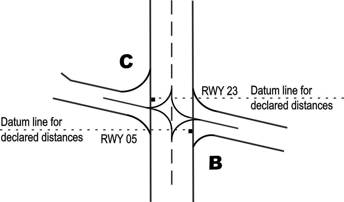
2 DETERMINATION OF DATUM LINE FOR INTERSECTION TAKE-OFF

The datum line from which the reduced runway declared distances for take-off should be determined is defined by the intersection of the downwind edge of the specific taxiway with the runway edge. The loss of runway length due to alignment of the aircraft prior to take-off shall be taken into account by the operators for the calculation of the aircraft's take-off mass (Annex 6, Part 1, paragraph 5.2.8).
 
EHTW AD 2.24 AERONAUTICAL CHARTS RELATED TO AN AERODROME
Charts
Pages
ADC
APDC
VAC
VAC - VFR procedures
EHTW AD 2.25 VISUAL SEGMENT SURFACE (VSS) PENETRATION
NIL