|
1
|
ARP coordinates and site at AD
|
522712N 0053050E
249 DEG GEO 755 M from TWR. |
|
2
|
Direction and distance from (city)
|
3.5 NM SSE of Lelystad.
|
|
3
|
Elevation / reference temperature
|
ELEV: -12 FT AMSL / T: 22 °C
|
|
4
|
Geoid undulation at AD ELEV PSN
|
141 FT
|
|
5
|
MAG VAR / annual change
|
3° E (2025) / 0.2° E
|
|
6
|
AD operator, address, telephone, telefax, email address, AFS, URL
|
LELYSTAD AIRPORT
P.O. BOX 2201 8203 AE LELYSTAD THE NETHERLANDS TEL: +31 (0)88 600 9770 email: [email protected] URL: https://www.lelystadairport.nl |
|
7
|
Types of traffic permitted (IFR/VFR)
|
IFR/VFR
|
|
8
|
Remarks
|
|
|
1
|
Use of aircraft stand ID signs, TWY guide lines and visual docking/parking guidance system at aircraft stands
|
Follow-me car and marshaller assistance AVBL on request at D- and L-apron.
|
|
2
|
RWY and TWY markings and LGT
|
RWY markings
|
|
3
|
Stop bars
|
NIL
|
|
4
|
Remarks
|
1) MAX wheel span information markings indicate TWYs where operations are limited to aircraft not exceeding the MAX outer main gear wheel span specified.
|
- Obstacles penetrate ICAO Annex 14 Volume I obstacle limitation surfaces.
- For obstacles in take-off areas see obstacle chart AOC type A RWY 05-23.
- No obstacle data sets AVBL for area 2 and 3.
- For obstacles in take-off areas see obstacle chart AOC type A RWY 05-23.
- No obstacle data sets AVBL for area 2 and 3.
|
1
|
Associated MET office
|
DE BILT
|
|
2
|
Hours of service
MET office outside hours |
Hours of service
H24 MET office outside hours NIL |
|
3
|
Office responsible for TAF preparation
Period of validity |
De Bilt
30 HR |
|
4
|
Trend forecast
Interval of issuance |
TREND
30 MIN, AVBL during AD OPR HR. |
|
5
|
Briefing/consultation provided
|
Self-briefing; briefing on request from MWO De Bilt by telephone after self-briefing.
TEL: 0900 202 3341 Briefing low level flights (IFR/VFR). TEL: 0900 202 3343 Briefing IFR flights above FL 100. TEL: 0900 202 3340 Briefing balloon flights within Amsterdam FIR. Weather bulletin (Dutch language) and METARs via Dutch public television 'Teletekst' page 707. |
|
6
|
Flight documentation
Language(s) used |
Reports, forecasts, charts.
English, Dutch. |
|
7
|
Charts and other information available for briefing or consultation
|
S, P, W, T
|
|
8
|
Supplementary equipment available for providing information
|
WXR, APT
|
|
9
|
ATS units provided with information
|
Lelystad TWR, Lelystad APP
|
|
10
|
Additional information (limitation of service, etc.)
|
Briefing/consultation provided
- charge for TEL briefings and consultations is € 0,50/MIN. |
|
RWY designation
|
True BRG
|
Dimensions of RWY (M)
|
Strength (PCN) and surface of RWY and SWY
|
THR coordinates
RWY end coordinates THR GUND |
THR ELEV and highest ELEV of TDZ of precision APCH RWY
|
|---|---|---|---|---|---|
|
1
|
2
|
3
|
4
|
5
|
6
|
|
05
|
047.54°
|
2700 x 45
|
RWY: 55/F/A/W/T
PCR 800/F/B/W/T Asphalt SWY: NIL |
THR:
522647.92N 0053010.10E RWY end: 522733.78N 0053132.16E THR GUND: 141.0 FT |
THR: -12.6 FT
TDZ: -12.0 FT |
|
23
|
227.55°
|
2700 x 45
|
RWY: 55/F/A/W/T
PCR 800/F/B/W/T Asphalt SWY: NIL |
THR:
522733.78N 0053132.16E RWY end: 522647.92N 0053010.10E THR GUND: 141.0 FT |
THR: -12.3 FT
TDZ: -12.0 FT |
|
RWY designation
|
Remarks
|
|---|---|
|
1
|
14
|
|
05
|
THR co-ordinates
- DTHR 300 M. RWY end co-ordinates - Displaced RWY end 300 M. Strip dimensions - Due to displaced threshold and displaced RWY end, the length and location of the RWY strip depend on the RWY direction and the operational use for take-off or landing: - RWY strip length for landing traffic: 2220 M. - RWY strip length for departing traffic: 2460 M. |
|
23
|
THR co-ordinates
- DTHR 300 M. RWY end co-ordinates - Displaced RWY end 300 M. Strip dimensions - Due to displaced threshold and displaced RWY end, the length and location of the RWY strip depend on the RWY direction and the operational use for take-off or landing: - RWY strip length for landing traffic: 2220 M. - RWY strip length for departing traffic: 2460 M. |
|
RWY designator
|
TORA
(M) |
TODA
(M) |
ASDA
(M) |
LDA
(M) |
Remarks
|
|---|---|---|---|---|---|
|
1
|
2
|
3
|
4
|
5
|
6
|
|
05
|
2400
|
2460
|
2400
|
2100
|
Take-off from intersection with TWY: N4
DTHR 300 M. |
|
05
|
2100
|
2160
|
2100
|
NIL
|
Take-off from intersection with TWY: N3
|
|
05
|
2100
|
2160
|
2100
|
NIL
|
Take-off from intersection with TWY: S7
|
|
05
|
1330
|
1390
|
1330
|
NIL
|
Take-off from intersection with TWY: S5
|
|
05
|
999
|
1059
|
999
|
NIL
|
Take-off from intersection with TWY: S4
Only AVBL for aircraft with a MAX outer main gear wheel span < 6 M. |
|
05
|
724
|
784
|
724
|
NIL
|
Take-off from intersection with TWY: S3
Only AVBL for aircraft with a MAX outer main gear wheel span < 6 M. |
|
23
|
2400
|
2460
|
2400
|
2100
|
Take-off from intersection with TWY: N1
DTHR 300 M. |
|
23
|
2100
|
2160
|
2100
|
NIL
|
Take-off from intersection with TWY: N2
|
|
23
|
2000
|
2060
|
2000
|
NIL
|
Take-off from intersection with TWY: S1
|
|
23
|
1700
|
1760
|
1700
|
NIL
|
Take-off from intersection with TWY: S2
Only AVBL for aircraft with a MAX outer main gear wheel span < 6 M. |
|
23
|
1386
|
1446
|
1386
|
NIL
|
Take-off from intersection with TWY: S3
Only AVBL for aircraft with a MAX outer main gear wheel span < 6 M. |
|
23
|
1111
|
1171
|
1111
|
NIL
|
Take-off from intersection with TWY: S4
Only AVBL for aircraft with a MAX outer main gear wheel span < 6 M. |
|
23
|
784
|
844
|
784
|
NIL
|
Take-off from intersection with TWY: S5
|
- RWY 05 and RWY 23: displaced RWY end 300 M.
- Backtracking of the runway not allowed beyond the displaced RWY ends.
- Backtracking of the runway not allowed beyond the displaced RWY ends.
|
RWY
designator |
RWY edge LGT
length spacing colour INTST |
RWY end LGT
colour WBAR |
SWY LGT
length colour |
Remarks
|
|---|---|---|---|---|
|
1
|
7
|
8
|
9
|
10
|
|
05
|
2400 M
60 M W LIH |
R
NIL |
NIL
|
RWY CL LGT
Colour: white from beginning of RWY to 900 M before RWY end LGT; white/red from 900 M to 300 M before RWY end LGT; red from 300 M before RWY end LGT, to RWY end LGT. No lights beyond RWY end LGT. RWY edge LGT Colour: red from beginning of RWY to DTHR; white from DTHR to 600 M before RWY end LGT; yellow from 600 M before RWY end LGT to RWY end LGT. No lights beyond RWY end LGT. |
|
23
|
2400 M
60 M W LIH |
R
NIL |
NIL
|
RWY CL LGT
Colour: white from beginning of RWY to 900 M before RWY end LGT; white/red from 900 M to 300 M before RWY end LGT; red from 300 M before RWY end LGT, to RWY end LGT. No lights beyond RWY end LGT. RWY edge LGT Colour: red from beginning of RWY to DTHR; white from DTHR to 600 M before RWY end LGT; yellow from 600 M before RWY end LGT to RWY end LGT. No lights beyond RWY end LGT. |
|
1
|
ABN/IBN location, characteristics and hours of operation
|
NIL
|
|
2
|
LDI location and LGT
Anemometer location and LGT |
LDI: NIL
Anemometer: 320 M WSW from THR RWY 23; and 412 M ENE from THR RWY 05, unlighted. |
|
3
|
TWY edge and centre line lighting
|
See EHLE AD 2.9.
|
|
4
|
Secondary power supply
Switchover time |
AVBL
Within 1 SEC for RENL and RCLL. Other lighting components: within 15 SEC. |
|
5
|
Remarks
|
NIL
|
|
1
|
Coordinates TLOF or THR of FATO
Geoid undulation |
522712.19N 0053036.16E
141 FT |
|
2
|
TLOF and/or FATO elevation
|
-12 FT
|
|
3
|
TLOF and FATO area dimensions, surface, strength, marking
|
TLOF: square 15 x 15 M / CONC. Edges marked in white, white ‘H’ in center.
FATO: rectangular 34 x 435 M / GRASS. Edges marked with red-white perimeter markers. |
|
4
|
True BRG of FATO
|
047.54 / 227.55°
|
|
5
|
Declared distances available
|
NIL
|
|
6
|
APCH and FATO lighting
|
NIL
|
|
7
|
Remarks
|
- Helicopter exercise area (HELEX) AVBL northeast of FATO for helicopter exercises up to 50 FT.
- FATO and HELEX only AVBL for local helicopter training operators. Use by other operators is only allowed with written approval by the AD operator. - FATO and HELEX only AVBL during UDP. |
|
Designation and lateral limits
|
Vertical limits
|
Airspace classification
|
ATS unit
call sign language(s) |
Transition altitude
|
Hours of applicability
|
Remarks
|
|---|---|---|---|---|---|---|
|
1
|
2
|
3
|
4
|
5
|
6
|
7
|
|
LELYSTAD CTR 1
(EHLE1) 522804N 0052511E - 521620N 0052511E - 521610N 0052449E - 521617N 0052154E - 522102N 0051512E - 522231N 0051518E - 522804N 0052511E. |
D
|
Lelystad Tower
English |
3000 FT AMSL
|
0600-2100 (0500-2000)
|
NIL
|
|
|
LELYSTAD CTR 2
(EHLE2) 523447N 0053713E - 523021N 0054350E - 522307N 0053050E - 522024N 0053357E - 521620N 0052511E - 522804N 0052511E - 523447N 0053713E. |
D
|
Lelystad Tower
English |
3000 FT AMSL
|
0600-2100 (0500-2000)
|
NIL
|
|
Service
designation |
Call sign
|
Channel(s)
|
SATVOICE NR
|
Logon address
|
Hours of operation
|
Remarks
|
|---|---|---|---|---|---|---|
|
1
|
2
|
3
|
4
|
5
|
6
|
7
|
|
APP
|
Lelystad Arrival
|
134.530
|
NIL
|
NIL
|
0600-2100 (0500-2000)
|
PRI
|
|
120.830
|
NIL
|
NIL
|
0600-2100 (0500-2000)
|
At ATC discretion.
|
||
|
TWR
|
Lelystad Tower
|
135.180
|
NIL
|
NIL
|
0600-2100 (0500-2000)
|
PRI
|
|
123.830
|
NIL
|
NIL
|
0600-2100 (0500-2000)
|
At ATC discretion.
|
||
|
Lelystad Delivery
|
123.680
|
NIL
|
NIL
|
0600-2100 (0500-2000)
|
Start-up control and clearance delivery. Preflight information IFR/VFR (incl. training flights). VDF.
|
|
|
123.830
|
NIL
|
NIL
|
0600-2100 (0500-2000)
|
At ATC discretion.
|
||
|
ATIS
|
Lelystad Information
|
120.730
|
NIL
|
NIL
|
H24
|
ATIS remains operational outside ATS OPR HR.
|
|
Type of aid
MAG VAR Supported OPS ILS CAT GBAS facility (VOR/ILS/MLS declination) |
ID
|
Frequency
CH Service provider Reference path ID |
Hours of operation
|
Position of transmitting antenna
|
DME: ELEV
transmitting antenna GBAS: ELEV ellipsoid height reference point SBAS: ellipsoid height LTP/FTP |
GBAS
reference point service volume radius |
Remarks
|
|---|---|---|---|---|---|---|---|
|
1
|
2
|
3
|
4
|
5
|
6
|
7
|
8
|
|
DME
|
FRO
|
111.400 MHz
CH 51X |
H24 |
522709.2N
0053029.0E |
0 FT
|
NIL
|
70 NM/450 FL
in sector 000°-360° MAG |
|
DME 05
|
ILSN
|
CH 22Y
|
H24
|
522652.3N
0053027.2E |
0 FT
|
NIL
|
Distance DME antenna/THR 05 is 349 M.
|
|
GP 05
|
ILSN
|
329.750 MHz
|
H24
|
522652.2N
0053027.2E |
NIL
|
NIL
|
NIL
|
|
LOC 05
(03° E) ILS CAT I/C/1 (decl.: 3°E) |
ILSN
|
108.550 MHz
|
H24
|
522741.7N
0053146.3E |
NIL
|
NIL
|
NIL
|
|
GPS
|
NIL
|
L1
1575.42 MHz |
H24
|
NIL
|
NIL
|
NIL
|
NIL
|
|
EGNOS
|
NIL
|
L1
1575.42 MHz |
H24
|
NIL
|
NIL
|
NIL
|
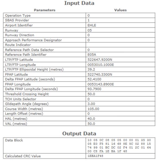
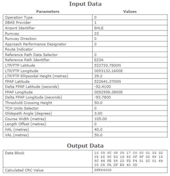
See EHLE AD 2.22 for FAS data block
|
The IFR departure and arrival routes are
not available
for scheduled and non-scheduled passenger flights UFN. Business aviation and GA operators shall contact airport authority.
For more information on the usage of LARSA (Lelystad airport runway scheduling application) see https://www.lelystadairport.nl.
Use of the VFR training circuit is limited to MON-SUN: 0600-1800 (0500-1700) during UDP.
Formation take-offs and landings are not allowed except with a pre-arranged operational agreement with ATC. Contact [email protected] for such an agreement.
Follow-me service is mandatory on:
- TWY S for aircraft with wingspan >24 M;
- TWYs S1, S5 and S7 for aircraft with outer main gear wheel span >9 M.
- TWYs S1, S5 and S7 for aircraft with outer main gear wheel span >9 M.
NIL
The instrument departure procedures are based on ICAO Annex 2 and on ICAO Documents 4444-ATM/501 (PANS-ATM), 7030 (SUPPS) and 8168-OPS/611 (PANS-OPS).
Pilots shall request start-up permission from ATC before starting engines. When applicable, report a cross-bleed start. The request for start-up shall be made to Lelystad Delivery after all preparations for departure have been made (doors closed etc.) and shall include:
Permission for start-up will be issued either immediately or at a specified time. The pilot shall be able to comply with start-up and taxi permission. Any delay in start-up or taxiing shall be reported to ATC immediately. In case of indefinite delay, the probable duration of delay will be given.
During the hours of the ATIS broadcast no MET information will be issued to departing aircraft except RVR (see EHLE AD 2.18).
Note:
when EHR49 is active the AMGOD and IDRID SID cannot be used.
Note:
when EHR8A is active the AMGOD SID cannot be used.
During the hours of the ATIS broadcast no MET information will be issued to departing aircraft except RVR (see EHLE AD 2.18).
The instrument departure procedures are laid down in standard instrument departures (SIDs). SIDs are published for RWY 05 and 23.
Note:
if not able to comply with the crossing conditions prescribed in the SIDs, inform Lelystad Delivery.
Note:
only flights of wake turbulence category LIGHT are allowed to file a flight plan with a requested flight level below FL 060. Expect additional ATC instructions.
Instructions containing deviations from the standard instrument departure may be added to the en-route or take-off clearance. These instructions may comprise maintaining a specified heading or temporary altitude restrictions; these additional instructions amend the relevant part of the SID only.
Due to interaction with other routes pilots must ensure strict compliance with the specified climb profile.
Aircraft shall request taxi clearance from Lelystad Tower.
- If possible call Amsterdam ACC Supervisor on telephone number +31 (0)20 406 3999.
Note: use telephone connection to mitigate COM failure only. All telephone calls will be automatically recorded.
- If telephone connection is disconnected prematurely (before read-back), revert to general communication failure procedure (see ENR 1.3 paragraph "Communication Failure").
Additionally, for departing flights, the following communication failure procedure applies:
- If a clearance to climb or re-routing instructions have not been given, comply with the route and altitude limitations detailed in the allocated standard instrument departure procedure or the departure instructions provided at take-off until the last waypoint has been reached.
Note: use telephone connection to mitigate COM failure only. All telephone calls will be automatically recorded.
- If telephone connection is disconnected prematurely (before read-back), revert to general communication failure procedure (see ENR 1.3 paragraph "Communication Failure").
- If a clearance to climb or re-routing instructions have not been given, comply with the route and altitude limitations detailed in the allocated standard instrument departure procedure or the departure instructions provided at take-off until the last waypoint has been reached.
- Transition altitude: 3000 ft AMSL.
- SIDs are based on an average climb rate of 2000 ft/min.
- SIDs shall be strictly adhered to.
- Initiate turns in due time in order not to overshoot radials.
- Turn radii based on a 25° bank angle.
- MAX 250 KIAS below FL 100 unless otherwise instructed.
- For continuous routings and crossing conditions on ATS routes as applicable see paragraph 1.4.3.
- IFR departures are not available for scheduled and non-scheduled passenger flights UFN (see AD 2.20).
- Both AMGOD and BERGI SIDs lead to AMGOD, be sure to follow the correct route.
- Both IDRID and VOLLA SIDs lead to IDRID, be sure to follow the correct route.
- BERGI, IDRID and VOLLA SIDs: only available for flights with requested flight/cruising level FL 140 or above.
- INKET SID: only for aircraft with destination EHRD.
- RUMER SID: only for aircraft with destination EHBD, EHBK, or EHEH.
- RNAV1 required.
Note:
REF EHLE AD 2.22 paragraph 1.2.2 "En-route clearance": if not able to comply with the crossing conditions prescribed in the SIDs, inform Lelystad Delivery before take-off.
See chart SID RWY 05.
|
AMGOD 1L
[AMGO1L] |
See paragraph 1.4.2 specific remark: 1, 6.
After departure climb to FL 060, expect FL 090 at KOKIP. |
||||||||||
|---|---|---|---|---|---|---|---|---|---|---|---|
| Serial number | Path descriptor | WPT ident | Fly-over |
Course/Track
°MAG / (°T) |
Recom. navaid | Dist. (NM) | Turn | Altitude (FT / FL) |
Speed
(KIAS) |
VPA (°) / TCH (FT) |
NAV
specification |
| 001 | CF | LE112 | N | 045 / (047.6) | - | - | - | - 3000 | - | - | RNAV 1 |
| 002 | TF | LE114 | N | 032 / (034.8) | - | 9.2 | - | - | - | - | RNAV 1 |
| 003 | TF | ERMUR | N | 321 / (323.3) | - | 5.4 | - | @ FL 060 | - | - | RNAV 1 |
| 004 | TF | ASNOM | N | 307 / (310.1) | - | 13.3 | - | - | - | - | RNAV 1 |
| 005 | TF | KOKIP | N | 275 / (277.8) | - | 51.3 | - | - | - | - | RNAV 1 |
| 006 | TF | AMGOD | N | 274 / (276.7) | - | 10.9 | - | - | - | - | RNAV 1 |
|
ARNEM 1L
[ARNE1L] |
See paragraph 1.4.2 specific remark: 6.
After departure climb to FL 060. |
||||||||||
|---|---|---|---|---|---|---|---|---|---|---|---|
| Serial number | Path descriptor | WPT ident | Fly-over |
Course/Track
°MAG / (°T) |
Recom. navaid | Dist. (NM) | Turn | Altitude (FT / FL) |
Speed
(KIAS) |
VPA (°) / TCH (FT) |
NAV
specification |
| 001 | CF | LE112 | N | 045 / (047.6) | - | - | - | - 3000 | - | - | RNAV 1 |
| 002 | TF | LE113 | N | 032 / (034.8) | - | 6.1 | - | - | - | - | RNAV 1 |
| 003 | TF | LE120 | N | 120 / (122.7) | - | 6.9 | - | @ FL 060 | - | - | RNAV 1 |
| 004 | TF | ARBEP | Y | 120 / (122.8) | - | 7.0 | - | - | - | - | RNAV 1 |
| 005 | CF | LE148 | N | 172 / (175.1) | - | - | - | - | - | - | RNAV 1 |
| 006 | TF | ARNEM | N | 176 / (179.1) | - | 13.9 | - | - | - | - | RNAV 1 |
|
BERGI 1Q
[BERG1Q] |
See paragraph 1.4.2 specific remark: 1, 3, 6.
After departure climb to FL 060. |
||||||||||
|---|---|---|---|---|---|---|---|---|---|---|---|
| Serial number | Path descriptor | WPT ident | Fly-over |
Course/Track
°MAG / (°T) |
Recom. navaid | Dist. (NM) | Turn | Altitude (FT / FL) |
Speed
(KIAS) |
VPA (°) / TCH (FT) |
NAV
specification |
| 001 | CF | LE112 | N | 045 / (047.6) | - | - | - | - 3000 | - | - | RNAV 1 |
| 002 | TF | LE114 | N | 032 / (034.8) | - | 9.2 | - | - | - | - | RNAV 1 |
| 003 | TF | ERMUR | N | 321 / (323.3) | - | 5.4 | - | @ FL 060 | - | - | RNAV 1 |
| 004 | TF | EDOXO | N | 286 / (289.1) | - | 11.4 | - | - | - | - | RNAV 1 |
| 005 | TF | LE142 | N | 258 / (260.6) | - | 31.2 | - | - | - | - | RNAV 1 |
| 006 | TF | BERGI | N | 302 / (304.6) | - | 7.4 | - | - | - | - | RNAV 1 |
| 007 | TF | AMGOD | N | 297 / (299.3) | - | 28.0 | - | - | - | - | RNAV 1 |
|
GRONY 1L
[GRON1L] |
See paragraph 1.4.2 specific remark: 6.
After departure climb to FL 060. |
||||||||||
|---|---|---|---|---|---|---|---|---|---|---|---|
| Serial number | Path descriptor | WPT ident | Fly-over |
Course/Track
°MAG / (°T) |
Recom. navaid | Dist. (NM) | Turn | Altitude (FT / FL) |
Speed
(KIAS) |
VPA (°) / TCH (FT) |
NAV
specification |
| 001 | CF | LE112 | N | 045 / (047.6) | - | - | - | - 3000 | - | - | RNAV 1 |
| 002 | TF | LE114 | N | 032 / (034.8) | - | 9.2 | - | - | - | - | RNAV 1 |
| 003 | TF | ERMUR | N | 321 / (323.3) | - | 5.4 | - | @ FL 060 | - | - | RNAV 1 |
| 004 | TF | LE146 | N | 350 / (352.9) | - | 8.3 | - | - | - | - | RNAV 1 |
| 005 | TF | LE147 | N | 015 / (018.2) | - | 6.0 | - | - | - | - | RNAV 1 |
| 006 | TF | GRONY | N | 050 / (052.4) | - | 16.7 | - | - | - | - | RNAV 1 |
|
IDRID 2L
[IDRI2L] |
See paragraph 1.4.2 specific remark: 2, 3, 6.
After departure climb to FL 060. |
||||||||||
|---|---|---|---|---|---|---|---|---|---|---|---|
| Serial number | Path descriptor | WPT ident | Fly-over |
Course/Track
°MAG / (°T) |
Recom. navaid | Dist. (NM) | Turn | Altitude (FT / FL) |
Speed
(KIAS) |
VPA (°) / TCH (FT) |
NAV
specification |
| 001 | CF | LE112 | N | 045 / (047.6) | - | - | - | - 3000 | - | - | RNAV 1 |
| 002 | TF | LE114 | N | 032 / (034.8) | - | 9.2 | - | - | - | - | RNAV 1 |
| 003 | TF | ERMUR | N | 321 / (323.3) | - | 5.4 | - | @ FL 060 | - | - | RNAV 1 |
| 004 | TF | ASNOM | N | 307 / (310.1) | - | 13.3 | - | - | - | - | RNAV 1 |
| 005 | TF | PETCA | N | 275 / (277.8) | - | 15.4 | - | - | - | - | RNAV 1 |
| 006 | TF | BAHSI | N | 210 / (212.4) | - | 32.6 | - | - | - | - | RNAV 1 |
| 007 | TF | VOLLA | N | 240 / (242.1) | - | 13.9 | - | - | - | - | RNAV 1 |
| 008 | TF | IDRID | N | 230 / (232.2) | - | 31.0 | - | - | - | - | RNAV 1 |
|
INKET 1L
[INKE1L] |
See paragraph 1.4.2 specific remark: 4, 6.
After departure climb to FL 060. |
||||||||||
|---|---|---|---|---|---|---|---|---|---|---|---|
| Serial number | Path descriptor | WPT ident | Fly-over |
Course/Track
°MAG / (°T) |
Recom. navaid | Dist. (NM) | Turn | Altitude (FT / FL) |
Speed
(KIAS) |
VPA (°) / TCH (FT) |
NAV
specification |
| 001 | CF | LE112 | N | 045 / (047.6) | - | - | - | - 3000 | - | - | RNAV 1 |
| 002 | TF | LE113 | N | 032 / (034.8) | - | 6.1 | - | - | - | - | RNAV 1 |
| 003 | TF | LE120 | N | 120 / (122.7) | - | 6.9 | - | @ FL 060 | - | - | RNAV 1 |
| 004 | TF | ARBEP | Y | 120 / (122.8) | - | 7.0 | - | - | - | - | RNAV 1 |
| 005 | CF | LE148 | N | 172 / (175.1) | - | - | - | - | - | - | RNAV 1 |
| 006 | TF | LE149 | N | 176 / (179.1) | - | 9.0 | - | - | - | - | RNAV 1 |
| 007 | TF | BRIAR | N | 235 / (237.9) | - | 13.2 | - | - | - | - | RNAV 1 |
| 008 | TF | IPMUR | N | 202 / (204.7) | - | 6.7 | - | - | - | - | RNAV 1 |
| 009 | TF | NEPTU | N | 252 / (254.5) | - | 12.3 | - | - | - | - | RNAV 1 |
| 010 | TF | PELUB | N | 247 / (249.4) | - | 9.6 | - | - | - | - | RNAV 1 |
| 011 | TF | INKET | N | 259 / (261.7) | - | 13.7 | - | - | - | - | RNAV 1 |
|
KUDAD 1L
[KUDA1L] |
See paragraph 1.4.2 specific remark: 6.
After departure climb to FL 060, expect FL 090 at IPMUR and FL 100 at WILEM. |
||||||||||
|---|---|---|---|---|---|---|---|---|---|---|---|
| Serial number | Path descriptor | WPT ident | Fly-over |
Course/Track
°MAG / (°T) |
Recom. navaid | Dist. (NM) | Turn | Altitude (FT / FL) |
Speed
(KIAS) |
VPA (°) / TCH (FT) |
NAV
specification |
| 001 | CF | LE112 | N | 045 / (047.6) | - | - | - | - 3000 | - | - | RNAV 1 |
| 002 | TF | LE113 | N | 032 / (034.8) | - | 6.1 | - | - | - | - | RNAV 1 |
| 003 | TF | LE120 | N | 120 / (122.7) | - | 6.9 | - | @ FL 060 | - | - | RNAV 1 |
| 004 | TF | ARBEP | Y | 120 / (122.8) | - | 7.0 | - | - | - | - | RNAV 1 |
| 005 | CF | LE148 | N | 172 / (175.1) | - | - | - | - | - | - | RNAV 1 |
| 006 | TF | LE149 | N | 176 / (179.1) | - | 9.0 | - | - | - | - | RNAV 1 |
| 007 | TF | BRIAR | N | 235 / (237.9) | - | 13.2 | - | - | - | - | RNAV 1 |
| 008 | TF | IPMUR | N | 202 / (204.7) | - | 6.7 | - | - | - | - | RNAV 1 |
| 009 | TF | NEPTU | N | 252 / (254.5) | - | 12.3 | - | - | - | - | RNAV 1 |
| 010 | TF | PELUB | N | 247 / (249.4) | - | 9.6 | - | - | - | - | RNAV 1 |
| 011 | TF | WILEM | N | 253 / (255.9) | - | 4.6 | - | - | - | - | RNAV 1 |
| 012 | TF | LE139 | N | 253 / (255.8) | - | 14.2 | - | - | - | - | RNAV 1 |
| 013 | TF | KUDAD | N | 203 / (205.7) | - | 6.9 | - | - | - | - | RNAV 1 |
|
NAPRO 1L
[NAPR1L] |
See paragraph 1.4.2 specific remark: 6.
After departure climb to FL 060. |
||||||||||
|---|---|---|---|---|---|---|---|---|---|---|---|
| Serial number | Path descriptor | WPT ident | Fly-over |
Course/Track
°MAG / (°T) |
Recom. navaid | Dist. (NM) | Turn | Altitude (FT / FL) |
Speed
(KIAS) |
VPA (°) / TCH (FT) |
NAV
specification |
| 001 | CF | LE112 | N | 045 / (047.6) | - | - | - | - 3000 | - | - | RNAV 1 |
| 002 | TF | LE113 | N | 032 / (034.8) | - | 6.1 | - | - | - | - | RNAV 1 |
| 003 | TF | LE120 | N | 120 / (122.7) | - | 6.9 | - | @ FL 060 | - | - | RNAV 1 |
| 004 | TF | ARBEP | Y | 120 / (122.8) | - | 7.0 | - | - | - | - | RNAV 1 |
| 005 | CF | LE148 | N | 172 / (175.1) | - | - | - | - | - | - | RNAV 1 |
| 006 | TF | ARNEM | N | 176 / (179.1) | - | 13.9 | - | - | - | - | RNAV 1 |
| 007 | TF | NAPRO | N | 180 / (182.6) | - | 14.5 | - | - | - | - | RNAV 1 |
|
RUMER 1L
[RUME1L] |
See paragraph 1.4.2 specific remark: 5, 6.
After departure climb to FL 060. |
||||||||||
|---|---|---|---|---|---|---|---|---|---|---|---|
| Serial number | Path descriptor | WPT ident | Fly-over |
Course/Track
°MAG / (°T) |
Recom. navaid | Dist. (NM) | Turn | Altitude (FT / FL) |
Speed
(KIAS) |
VPA (°) / TCH (FT) |
NAV
specification |
| 001 | CF | LE112 | N | 045 / (047.6) | - | - | - | - 3000 | - | - | RNAV 1 |
| 002 | TF | LE113 | N | 032 / (034.8) | - | 6.1 | - | - | - | - | RNAV 1 |
| 003 | TF | LE120 | N | 120 / (122.7) | - | 6.9 | - | @ FL 060 | - | - | RNAV 1 |
| 004 | TF | ARBEP | Y | 120 / (122.8) | - | 7.0 | - | - | - | - | RNAV 1 |
| 005 | CF | LE148 | N | 172 / (175.1) | - | - | - | - | - | - | RNAV 1 |
| 006 | TF | ARNEM | N | 176 / (179.1) | - | 13.9 | - | - | - | - | RNAV 1 |
| 007 | TF | LE145 | N | 180 / (182.6) | - | 7.9 | - | - | - | - | RNAV 1 |
| 008 | TF | BASGU | N | 246 / (248.4) | - | 8.7 | - | - | - | - | RNAV 1 |
| 009 | TF | RUMER | N | 173 / (175.8) | - | 17.6 | - | - | - | - | RNAV 1 |
|
VOLLA 2Q
[VOLL2Q] |
See paragraph 1.4.2 specific remark: 2, 3, 6.
After departure climb to FL 060. |
||||||||||
|---|---|---|---|---|---|---|---|---|---|---|---|
| Serial number | Path descriptor | WPT ident | Fly-over |
Course/Track
°MAG / (°T) |
Recom. navaid | Dist. (NM) | Turn | Altitude (FT / FL) |
Speed
(KIAS) |
VPA (°) / TCH (FT) |
NAV
specification |
| 001 | CF | LE112 | N | 045 / (047.6) | - | - | - | - 3000 | - | - | RNAV 1 |
| 002 | TF | LE114 | N | 032 / (034.8) | - | 9.2 | - | - | - | - | RNAV 1 |
| 003 | TF | ERMUR | N | 321 / (323.3) | - | 5.4 | - | @ FL 060 | - | - | RNAV 1 |
| 004 | TF | EDOXO | N | 286 / (289.1) | - | 11.4 | - | - | - | - | RNAV 1 |
| 005 | TF | LE141 | N | 258 / (260.6) | - | 21.8 | - | - | - | - | RNAV 1 |
| 006 | TF | BASHI | N | 210 / (212.3) | - | 20.1 | - | - | - | - | RNAV 1 |
| 007 | TF | VOLLA | N | 240 / (242.1) | - | 13.9 | - | - | - | - | RNAV 1 |
| 008 | TF | IDRID | N | 230 / (232.2) | - | 31.0 | - | - | - | - | RNAV 1 |
See chart SID RWY 23.
|
AMGOD 1M
[AMGO1M] |
See paragraph 1.4.2 specific remark: 1, 6.
Minimum climb gradient: 4.0 % to 500 FT AMSL. After departure climb to FL 060, expect FL 090 at KOKIP. |
||||||||||
|---|---|---|---|---|---|---|---|---|---|---|---|
| Serial number | Path descriptor | WPT ident | Fly-over |
Course/Track
°MAG / (°T) |
Recom. navaid | Dist. (NM) | Turn | Altitude (FT / FL) |
Speed
(KIAS) |
VPA (°) / TCH (FT) |
NAV
specification |
| 001 | CA | - | - | 225 / (227.7) | - | - | - | + 500 | - | - | RNAV 1 |
| 002 | DF | LE101 | N | - | - | - | - | - | - | - | RNAV 1 |
| 003 | TF | LE102 | N | 135 / (137.5) | - | 3.3 | - | - 2000 | - 210 | - | RNAV 1 |
| 004 | TF | ASBES | N | 058 / (060.5) | - | 6.2 | - | @ 3000 | - | - | RNAV 1 |
| 005 | TF | DOTIX | N | 058 / (060.6) | - | 9.0 | - | @ FL 060 | - | - | RNAV 1 |
| 006 | TF | LE107 | N | 358 / (000.4) | - | 5.1 | - | - | - | - | RNAV 1 |
| 007 | TF | ERMUR | N | 321 / (323.4) | - | 10.5 | - | - | - | - | RNAV 1 |
| 008 | TF | ASNOM | N | 307 / (310.1) | - | 13.3 | - | - | - | - | RNAV 1 |
| 009 | TF | KOKIP | N | 275 / (277.8) | - | 51.3 | - | - | - | - | RNAV 1 |
| 010 | TF | AMGOD | N | 274 / (276.7) | - | 10.9 | - | - | - | - | RNAV 1 |
|
ARNEM 2M
[ARNE2M] |
See paragraph 1.4.2 specific remark: 6.
Minimum climb gradient: 4.0 % to 500 FT AMSL. After departure climb to FL 060, expect FL 090 at ARNEM. |
||||||||||
|---|---|---|---|---|---|---|---|---|---|---|---|
| Serial number | Path descriptor | WPT ident | Fly-over |
Course/Track
°MAG / (°T) |
Recom. navaid | Dist. (NM) | Turn | Altitude (FT / FL) |
Speed
(KIAS) |
VPA (°) / TCH (FT) |
NAV
specification |
| 001 | CA | - | - | 225 / (227.7) | - | - | - | + 500 | - | - | RNAV 1 |
| 002 | DF | LE101 | N | - | - | - | - | - | - | - | RNAV 1 |
| 003 | TF | LE102 | N | 135 / (137.5) | - | 3.3 | - | - 2000 | - 210 | - | RNAV 1 |
| 004 | TF | ASBES | N | 058 / (060.5) | - | 6.2 | - | @ 3000 | - | - | RNAV 1 |
| 005 | TF | DOTIX | N | 058 / (060.6) | - | 9.0 | - | @ FL 060 | - | - | RNAV 1 |
| 006 | TF | LE152 | N | 058 / (060.8) | - | 4.5 | - | - | - | - | RNAV 1 |
| 007 | TF | ZITFA | N | 120 / (122.9) | - | 4.7 | - | - | - | - | RNAV 1 |
| 008 | TF | LE148 | N | 172 / (175.1) | - | 8.8 | - | - | - | - | RNAV 1 |
| 009 | TF | ARNEM | N | 176 / (179.1) | - | 13.9 | - | - | - | - | RNAV 1 |
|
BERGI 1U
[BERG1U] |
See paragraph 1.4.2 specific remark: 1, 3, 6.
Minimum climb gradient: 4.0 % to 500 FT AMSL. After departure climb to FL 060. |
||||||||||
|---|---|---|---|---|---|---|---|---|---|---|---|
| Serial number | Path descriptor | WPT ident | Fly-over |
Course/Track
°MAG / (°T) |
Recom. navaid | Dist. (NM) | Turn | Altitude (FT / FL) |
Speed
(KIAS) |
VPA (°) / TCH (FT) |
NAV
specification |
| 001 | CA | - | - | 225 / (227.7) | - | - | - | + 500 | - | - | RNAV 1 |
| 002 | DF | LE101 | N | - | - | - | - | - | - | - | RNAV 1 |
| 003 | TF | LE102 | N | 135 / (137.5) | - | 3.3 | - | - 2000 | - 210 | - | RNAV 1 |
| 004 | TF | ASBES | N | 058 / (060.5) | - | 6.2 | - | @ 3000 | - | - | RNAV 1 |
| 005 | TF | DOTIX | N | 058 / (060.6) | - | 9.0 | - | @ FL 060 | - | - | RNAV 1 |
| 006 | TF | LE107 | N | 358 / (000.4) | - | 5.1 | - | - | - | - | RNAV 1 |
| 007 | TF | ERMUR | N | 321 / (323.4) | - | 10.5 | - | - | - | - | RNAV 1 |
| 008 | TF | EDOXO | N | 286 / (289.1) | - | 11.4 | - | - | - | - | RNAV 1 |
| 009 | TF | LE142 | N | 258 / (260.6) | - | 31.2 | - | - | - | - | RNAV 1 |
| 010 | TF | BERGI | N | 302 / (304.6) | - | 7.4 | - | - | - | - | RNAV 1 |
| 011 | TF | AMGOD | N | 297 / (299.3) | - | 28.0 | - | - | - | - | RNAV 1 |
|
GRONY 1M
[GRON1M] |
See paragraph 1.4.2 specific remark: 6.
Minimum climb gradient: 4.0 % to 500 FT AMSL. After departure climb to FL 060. |
||||||||||
|---|---|---|---|---|---|---|---|---|---|---|---|
| Serial number | Path descriptor | WPT ident | Fly-over |
Course/Track
°MAG / (°T) |
Recom. navaid | Dist. (NM) | Turn | Altitude (FT / FL) |
Speed
(KIAS) |
VPA (°) / TCH (FT) |
NAV
specification |
| 001 | CA | - | - | 225 / (227.7) | - | - | - | + 500 | - | - | RNAV 1 |
| 002 | DF | LE101 | N | - | - | - | - | - | - | - | RNAV 1 |
| 003 | TF | LE102 | N | 135 / (137.5) | - | 3.3 | - | - 2000 | - 210 | - | RNAV 1 |
| 004 | TF | ASBES | N | 058 / (060.5) | - | 6.2 | - | @ 3000 | - | - | RNAV 1 |
| 005 | TF | DOTIX | N | 058 / (060.6) | - | 9.0 | - | @ FL 060 | - | - | RNAV 1 |
| 006 | TF | LE107 | N | 358 / (000.4) | - | 5.1 | - | - | - | - | RNAV 1 |
| 007 | TF | ERMUR | N | 321 / (323.4) | - | 10.5 | - | - | - | - | RNAV 1 |
| 008 | TF | LE146 | N | 350 / (352.9) | - | 8.3 | - | - | - | - | RNAV 1 |
| 009 | TF | LE147 | N | 015 / (018.2) | - | 6.0 | - | - | - | - | RNAV 1 |
| 010 | TF | GRONY | N | 050 / (052.4) | - | 16.7 | - | - | - | - | RNAV 1 |
|
IDRID 2M
[IDRI2M] |
See paragraph 1.4.2 specific remark: 2, 3, 6.
Minimum climb gradient: 4.0 % to 500 FT AMSL. After departure climb to FL 060. |
||||||||||
|---|---|---|---|---|---|---|---|---|---|---|---|
| Serial number | Path descriptor | WPT ident | Fly-over |
Course/Track
°MAG / (°T) |
Recom. navaid | Dist. (NM) | Turn | Altitude (FT / FL) |
Speed
(KIAS) |
VPA (°) / TCH (FT) |
NAV
specification |
| 001 | CA | - | - | 225 / (227.7) | - | - | - | + 500 | - | - | RNAV 1 |
| 002 | DF | LE101 | N | - | - | - | - | - | - | - | RNAV 1 |
| 003 | TF | LE102 | N | 135 / (137.5) | - | 3.3 | - | - 2000 | - 210 | - | RNAV 1 |
| 004 | TF | ASBES | N | 058 / (060.5) | - | 6.2 | - | @ 3000 | - | - | RNAV 1 |
| 005 | TF | DOTIX | N | 058 / (060.6) | - | 9.0 | - | @ FL 060 | - | - | RNAV 1 |
| 006 | TF | LE107 | N | 358 / (000.4) | - | 5.1 | - | - | - | - | RNAV 1 |
| 007 | TF | ERMUR | N | 321 / (323.4) | - | 10.5 | - | - | - | - | RNAV 1 |
| 008 | TF | ASNOM | N | 307 / (310.1) | - | 13.3 | - | - | - | - | RNAV 1 |
| 009 | TF | PETCA | N | 275 / (277.8) | - | 15.4 | - | - | - | - | RNAV 1 |
| 010 | TF | BAHSI | N | 210 / (212.4) | - | 32.6 | - | - | - | - | RNAV 1 |
| 011 | TF | VOLLA | N | 240 / (242.1) | - | 13.9 | - | - | - | - | RNAV 1 |
| 012 | TF | IDRID | N | 230 / (232.2) | - | 31.0 | - | - | - | - | RNAV 1 |
|
INKET 2M
[INKE2M] |
See paragraph 1.4.2 specific remark: 4, 6.
Minimum climb gradient: 4.0 % to 500 FT AMSL. After departure climb to FL 060. |
||||||||||
|---|---|---|---|---|---|---|---|---|---|---|---|
| Serial number | Path descriptor | WPT ident | Fly-over |
Course/Track
°MAG / (°T) |
Recom. navaid | Dist. (NM) | Turn | Altitude (FT / FL) |
Speed
(KIAS) |
VPA (°) / TCH (FT) |
NAV
specification |
| 001 | CA | - | - | 225 / (227.7) | - | - | - | + 500 | - | - | RNAV 1 |
| 002 | DF | LE101 | N | - | - | - | - | - | - | - | RNAV 1 |
| 003 | TF | LE102 | N | 135 / (137.5) | - | 3.3 | - | - 2000 | - 210 | - | RNAV 1 |
| 004 | TF | ASBES | N | 058 / (060.5) | - | 6.2 | - | @ 3000 | - | - | RNAV 1 |
| 005 | TF | DOTIX | N | 058 / (060.6) | - | 9.0 | - | @ FL 060 | - | - | RNAV 1 |
| 006 | TF | LE152 | N | 058 / (060.8) | - | 4.5 | - | - | - | - | RNAV 1 |
| 007 | TF | ZITFA | N | 120 / (122.9) | - | 4.7 | - | - | - | - | RNAV 1 |
| 008 | TF | LE148 | N | 172 / (175.1) | - | 8.8 | - | - | - | - | RNAV 1 |
| 009 | TF | LE149 | N | 176 / (179.1) | - | 9.0 | - | - | - | - | RNAV 1 |
| 010 | TF | BRIAR | N | 235 / (237.9) | - | 13.2 | - | - | - | - | RNAV 1 |
| 011 | TF | IPMUR | N | 202 / (204.7) | - | 6.7 | - | - | - | - | RNAV 1 |
| 012 | TF | NEPTU | N | 252 / (254.5) | - | 12.3 | - | - | - | - | RNAV 1 |
| 013 | TF | PELUB | N | 247 / (249.4) | - | 9.6 | - | - | - | - | RNAV 1 |
| 014 | TF | INKET | N | 259 / (261.7) | - | 13.7 | - | - | - | RNAV 1 | |
|
KUDAD 2M
[KUDA2M] |
See paragraph 1.4.2 specific remark: 6.
Minimum climb gradient: 4.0 % to 500 FT AMSL. After departure climb to FL 060, expect FL 090 at IPMUR and FL 100 at WILEM. |
||||||||||
|---|---|---|---|---|---|---|---|---|---|---|---|
| Serial number | Path descriptor | WPT ident | Fly-over |
Course/Track
°MAG / (°T) |
Recom. navaid | Dist. (NM) | Turn | Altitude (FT / FL) |
Speed
(KIAS) |
VPA (°) / TCH (FT) |
NAV
specification |
| 001 | CA | - | - | 225 / (227.9) | - | - | - | + 500 | - | - | RNAV 1 |
| 002 | DF | LE101 | N | - | - | - | - | - | - | - | RNAV 1 |
| 003 | TF | LE102 | N | 135 / (137.5) | - | 3.3 | - | - 2000 | - 210 | - | RNAV 1 |
| 004 | TF | ASBES | N | 058 / (060.5) | - | 6.2 | - | @ 3000 | - | - | RNAV 1 |
| 005 | TF | DOTIX | N | 058 / (060.6) | - | 9.0 | - | @ FL 060 | - | - | RNAV 1 |
| 006 | TF | LE152 | N | 058 / (060.8) | - | 4.5 | - | - | - | - | RNAV 1 |
| 007 | TF | ZITFA | N | 120 / (122.9) | - | 4.7 | - | - | - | - | RNAV 1 |
| 008 | TF | LE148 | N | 172 / (175.1) | - | 8.8 | - | - | - | - | RNAV 1 |
| 009 | TF | LE149 | N | 176 / (179.1) | - | 9.0 | - | - | - | - | RNAV 1 |
| 010 | TF | BRIAR | N | 235 / (237.9) | - | 13.2 | - | - | - | - | RNAV 1 |
| 011 | TF | IPMUR | N | 202 / (204.7) | - | 6.7 | - | - | - | - | RNAV 1 |
| 012 | TF | NEPTU | N | 252 / (254.5) | - | 12.3 | - | - | - | - | RNAV 1 |
| 013 | TF | PELUB | N | 247 / (249.4) | - | 9.6 | - | - | - | - | RNAV 1 |
| 014 | TF | WILEM | N | 253 / (255.9) | - | 4.6 | - | - | - | - | RNAV 1 |
| 015 | TF | LE139 | N | 253 / (255.8) | - | 14.2 | - | - | - | - | RNAV 1 |
| 016 | TF | KUDAD | N | 203 / (205.7) | - | 6.9 | - | - | - | - | RNAV 1 |
|
NAPRO 2M
[NAPR2M] |
See paragraph 1.4.2 specific remark: 6.
Minimum climb gradient: 4.0 % to 500 FT AMSL. After departure climb to FL 060. |
||||||||||
|---|---|---|---|---|---|---|---|---|---|---|---|
| Serial number | Path descriptor | WPT ident | Fly-over |
Course/Track
°MAG / (°T) |
Recom. navaid | Dist. (NM) | Turn | Altitude (FT / FL) |
Speed
(KIAS) |
VPA (°) / TCH (FT) |
NAV
specification |
| 001 | CA | - | - | 225 / (227.9) | - | - | - | + 500 | - | - | RNAV 1 |
| 002 | DF | LE101 | N | - | - | - | - | - | - | - | RNAV 1 |
| 003 | TF | LE102 | N | 135 / (137.5) | - | 3.3 | - | - 2000 | - 210 | - | RNAV 1 |
| 004 | TF | ASBES | N | 058 / (060.5) | - | 6.2 | - | @ 3000 | - | - | RNAV 1 |
| 005 | TF | DOTIX | N | 058 / (060.6) | - | 9.0 | - | @ FL 060 | - | - | RNAV 1 |
| 006 | TF | LE152 | N | 058 / (060.8) | - | 4.5 | - | - | - | - | RNAV 1 |
| 007 | TF | ZITFA | N | 120 / (122.9) | - | 4.7 | - | - | - | - | RNAV 1 |
| 008 | TF | LE148 | N | 172 / (175.1) | - | 8.8 | - | - | - | - | RNAV 1 |
| 009 | TF | ARNEM | N | 176 / (179.1) | - | 13.9 | - | - | - | - | RNAV 1 |
| 010 | TF | NAPRO | N | 180 / (182.6) | - | 14.5 | - | - | - | - | RNAV 1 |
|
RUMER 2M
[RUME2M] |
See paragraph 1.4.2 specific remark: 5, 6.
Minimum climb gradient: 4.0 % to 500 FT AMSL. After departure climb to FL 060. |
||||||||||
|---|---|---|---|---|---|---|---|---|---|---|---|
| Serial number | Path descriptor | WPT ident | Fly-over |
Course/Track
°MAG / (°T) |
Recom. navaid | Dist. (NM) | Turn | Altitude (FT / FL) |
Speed
(KIAS) |
VPA (°) / TCH (FT) |
NAV
specification |
| 001 | CA | - | - | 225 / (227.9) | - | - | - | + 500 | - | - | RNAV 1 |
| 002 | DF | LE101 | N | - | - | - | - | - | - | - | RNAV 1 |
| 003 | TF | LE102 | N | 135 / (137.5) | - | 3.3 | - | - 2000 | - 210 | - | RNAV 1 |
| 004 | TF | ASBES | N | 058 / (060.5) | - | 6.2 | - | @ 3000 | - | - | RNAV 1 |
| 005 | TF | DOTIX | N | 058 / (060.6) | - | 9.0 | - | @ FL 060 | - | - | RNAV 1 |
| 006 | TF | LE152 | N | 058 / (060.8) | - | 4.5 | - | - | - | - | RNAV 1 |
| 007 | TF | ZITFA | N | 120 / (122.9) | - | 4.7 | - | - | - | - | RNAV 1 |
| 008 | TF | LE148 | N | 172 / (175.1) | - | 8.8 | - | - | - | - | RNAV 1 |
| 009 | TF | ARNEM | N | 176 / (179.1) | - | 13.9 | - | - | - | - | RNAV 1 |
| 010 | TF | LE145 | N | 180 / (182.6) | - | 7.9 | - | - | - | - | RNAV 1 |
| 011 | TF | BASGU | N | 246 / (248.4) | - | 8.7 | - | - | - | - | RNAV 1 |
| 012 | TF | RUMER | N | 173 / (175.8) | - | 17.6 | - | - | - | - | RNAV 1 |
|
VOLLA 2U
[VOLL2U] |
See paragraph 1.4.2 specific remark: 2, 3, 6.
Minimum climb gradient: 4.0 % to 500 FT AMSL. After departure climb to FL 060. |
||||||||||
|---|---|---|---|---|---|---|---|---|---|---|---|
| Serial number | Path descriptor | WPT ident | Fly-over |
Course/Track
°MAG / (°T) |
Recom. navaid | Dist. (NM) | Turn | Altitude (FT / FL) |
Speed
(KIAS) |
VPA (°) / TCH (FT) |
NAV
specification |
| 001 | CA | - | - | 225 / (227.7) | - | - | - | + 500 | - | - | RNAV 1 |
| 002 | DF | LE101 | N | - | - | - | - | - | - | - | RNAV 1 |
| 003 | TF | LE102 | N | 135 / (137.5) | - | 3.3 | - | - 2000 | - 210 | - | RNAV 1 |
| 004 | TF | ASBES | N | 058 / (060.5) | - | 6.2 | - | @ 3000 | - | - | RNAV 1 |
| 005 | TF | DOTIX | N | 058 / (060.6) | - | 9.0 | - | @ FL 060 | - | - | RNAV 1 |
| 006 | TF | LE107 | N | 358 / (000.4) | - | 5.1 | - | - | - | - | RNAV 1 |
| 007 | TF | ERMUR | N | 321 / (323.4) | - | 10.5 | - | - | - | - | RNAV 1 |
| 008 | TF | EDOXO | N | 286 / (289.1) | - | 11.4 | - | - | - | - | RNAV 1 |
| 009 | TF | LE141 | N | 258 / (260.6) | - | 21.8 | - | - | - | - | RNAV 1 |
| 010 | TF | BAHSI | N | 210 / (212.3) | - | 20.1 | - | - | - | - | RNAV 1 |
| 011 | TF | VOLLA | N | 240 / (242.1) | - | 13.9 | - | - | - | - | RNAV 1 |
| 012 | TF | IDRID | N | 230 / (232.2) | - | 31.0 | - | - | - | - | RNAV 1 |
The arrival, instrument approach and holding procedures are based on ICAO Annex 2 and on ICAO Documents 4444-ATM/501 (PANS-ATM), 7030 (SUPPS) and 8168-OPS/611 (PANS-OPS).
Note:
an aircraft vectored to intercept final approach shall report to ATC when established on the final approach track (ICAO Doc 4444-ATM/501 (PANS-ATM) chapter 8.9.4.1).
RNAV to ILS or LOC approach:
RNP approach:
Remarks:
- Notice the large localizer interception angle of 88 degrees.
- Notice the short distance between IF and FAF available for final course interception. The length of the intermediate segment (2.2 NM) is shorter than the ICAO minimum in case of a final approach interception angle of more than 60 degrees (3.0 NM).
Visual approach allowed only when in the final approach segment.
Circling approaches are not allowed.
For the use of all IFR approach procedures to EHLE the following requirements are applicable:
- The aircraft must be equipped with an FMS comprising a pre-loaded navigation database and a navigation display.
- The aircraft FMS must use GNSS as the primary navigation sensor.
- The operator must hold an RNAV1 operations approval issued by their state of registry, which is compliant with the ICAO Document 9613 Performance-based Navigation (PBN) Manual or equivalent.
- The operator must hold an RNP APCH operations approval issued by their state of registry, which is compliant with the ICAO Document 9613 Performance-based Navigation (PBN) Manual or equivalent.
See relevant instrument approach chart.
After second missed approach, follow the relevant SID to the alternate airport.
After second missed approach, follow the relevant SID to the alternate airport.
- If possible call Amsterdam ACC Supervisor on telephone number +31 (0)20 406 3999.
Note: use telephone connection to mitigate COM failure only. All telephone calls will be automatically recorded.
- If telephone connection is disconnected prematurely (before read-back), revert to general communication failure procedure.
For the general procedures for IFR flights see ENR 1.3 paragraph "Communication Failure". Additionally, for arriving flights, the following communication failure procedures apply.
Note: use telephone connection to mitigate COM failure only. All telephone calls will be automatically recorded.
- If telephone connection is disconnected prematurely (before read-back), revert to general communication failure procedure.
- Proceed according to the current flight plan route to the appropriate IAF (BADEX or EKNON);
- Commence descent to cross BADEX or EKNON at FL 060; except traffic via RKN: cross NILMI at FL 060;
- At BADEX or EKNON carry out an instrument procedure to the received and acknowledged runway or the runway-in-use as is included in the ATIS broadcast (see relevant instrument approach chart).
See the relevant instrument approach.
After second missed approach, follow the relevant SID to the alternate airport.
After second missed approach, follow the relevant SID to the alternate airport.
Note:
recommended navaid for selection of MAG station declination only.
Note:
for positions of LExxx-waypoints see relevant instrument approach charts.
| Serial number | Path descriptor | WPT ident | Fly-over |
Course/Track
°MAG / (°T) |
Recom. navaid | Dist. (NM) | Turn | Altitude (FT / FL) |
Speed
(KIAS) |
VPA (°) / TCH (FT) |
NAV
specification |
|---|---|---|---|---|---|---|---|---|---|---|---|
| 001 | IF | BADEX | - | - | - | - | - | + FL060 | - | - | - |
| 002 | TF | NILMI | - | 305 / (308.0) | - | 12.1 | - | - FL060 | - | - | RNAV1 |
| 003 | TF | LE118 | - | 238 / (240.9) | - | 3.3 | - | + FL050 | - | - | RNAV1 |
| 004 | IF | EKNON | - | - | - | - | - | @ FL060 | - | - | - |
| 005 | TF | LE118 | - | 180 / (183.0) | - | 14.0 | - | + FL050 | - | - | RNAV1 |
| 006 | IF | LE118 | - | - | - | - | - | +FL050 | - | - | - |
| 007 | TF | ASBES | - | 238 / (240.6) | - | 16.3 | - | @ 3000 | - | - | RNAV1 |
| 008 | TF | LE103 | - | 238 / (240.5) | - | 4.1 | - | - | - | - | RNAV1 |
| 009 | TF | LE137 | - | 232 / (234.7) | - | 3.1 | - | @ 2000 | - | - | RNAV1 |
| 010 | TF | XIDES | - | 229 / (231.9) | - | 3.0 | - | @ 2000 | - 185 | - | RNAV1 |
| 011 | TF | UPLOS | - | 316 / (319.1) | - | 3.2 | - | + 1700 | - | - | RNAV1 |
| 012 | CF | LE134 | - | 045 / (047.5) | ILSN | 3.0 | - | + 1700 | - | - | - |
| 013 | CF | THR 05 | Y | 045 / (047.5) | ILSN | 5.2 | - | - | - | -3.00/50 | - |
| 014 | CF | LE112 | - | 045 / (048.0) | ILSN | 5.3 | - | - | - | - | RNAV1 |
| 015 | TF | LE113 | - | 032 / (034.8) | - | 6.1 | - | - | - | - | RNAV1 |
| 016 | TF | LE150 | Y | 120 / (122.8) | - | 4.2 | - | - | - 220 | - | RNAV1 |
| 017 | CF | ASBES | - | 238 / (241.0) | ILSN | 13.5 | R | @ 3000 | - 220 | - | RNAV1 |
| Serial number | Path descriptor | WPT ident | Fly-over |
Course/Track
°MAG / (°T) |
Recom. navaid | Dist. (NM) | Turn | Altitude (FT / FL) |
Speed
(KIAS) |
VPA (°) / TCH (FT) |
NAV
specification |
|---|---|---|---|---|---|---|---|---|---|---|---|
| 001 | IF | BADEX | - | - | - | - | - | + FL060 | - | - | - |
| 002 | TF | NILMI | - | 305 / (308.0) | - | 12.1 | - | - FL060 | - | - | RNAV1 |
| 003 | TF | LE118 | - | 238 / (240.9) | - | 3.3 | - | + FL050 | - | - | RNAV1 |
| 004 | IF | EKNON | - | - | - | - | - | @ FL060 | - | - | - |
| 005 | TF | LE118 | - | 180/ (183.0) | - | 14.0 | - | + FL050 | - | - | RNAV1 |
| 006 | IF | LE118 | - | - | - | - | - | +FL050 | - | - | - |
| 007 | TF | ASBES | - | 238 / (240.6) | - | 16.3 | - | @ 3000 | - | - | RNAV1 |
| 008 | TF | LE103 | - | 238 / (240.5) | - | 4.1 | - | - | - | - | RNAV1 |
| 009 | TF | LE137 | - | 232 / (234.7) | - | 3.1 | - | @ 2000 | - | - | RNAV1 |
| 010 | TF | XIDES | - | 229 / (231.9) | - | 3.0 | - | @ 2000 | - 185 | - | RNAV1 |
| 011 | TF | UPLOS | - | 316 / (319.1) | - | 3.2 | - | + 1700 | - | - | RNAV1 |
| 012 | TF | LE134 | - | 045 / (047.5) | - | 3.0 | - | + 1700 | - | - | RNP APCH |
| 013 | TF | THR 05 | Y | 045 / (047.5) | - | 5.2 | - | - | - | -3.00/50 | RNP APCH |
| 014 | CF | LE112 | - | 045 / (048.0) | ILSN | 5.3 | - | - | - | - | RNAV1 |
| 015 | TF | LE113 | - | 032 / (034.8) | - | 6.1 | - | - | - | - | RNAV1 |
| 016 | TF | LE150 | Y | 120 / (122.8) | - | 4.2 | - | - | - 220 | - | RNAV1 |
| 017 | CF | ASBES | - | 238 / (241.0) | ILSN | 13.5 | R | @ 3000 | - 220 | - | RNAV1 |
| Serial number | Path descriptor | WPT ident | Fly-over |
Course/Track
°MAG / (°T) |
Recom. navaid | Dist. (NM) | Turn | Altitude (FT / FL) |
Speed
(KIAS) |
VPA (°) / TCH (FT) |
NAV
specification |
|---|---|---|---|---|---|---|---|---|---|---|---|
| 001 | IF | BADEX | - | - | - | - | - | + FL060 | - | - | - |
| 002 | TF | NILMI | - | 305 / (308.0) | - | 12.1 | - | - FL060 | - | - | RNAV1 |
| 003 | TF | LE110 | - | 305 / (307.9) | - | 5.1 | - | + FL050 | - | - | RNAV1 |
| 004 | TF | IDGOK | - | 268 / (270.4) | - | 6.0 | - | - | - | - | RNAV1 |
| 005 | TF | KUVOS | - | 225 / (227.7) | - | 3.0 | - | + 3000 | - | - | RNAV1 |
| 006 | IF | EKNON | - | - | - | - | - | @ FL060 | - | - | - |
| 007 | TF | LE122 | - | 218 / (220.8) | - | 7.2 | - | + FL050 | - | - | RNAV1 |
| 008 | TF | IDGOK | - | 218 / (220.7) | - | 4.9 | - | - | - | - | RNAV1 |
| 009 | TF | KUVOS | - | 225 / (227.7) | - | 3.0 | - | + 3000 | - | - | RNAV1 |
| 010 | IF | KUVOS | - | - | - | - | - | + 3000 | - | - | - |
| 011 | TF | LE124 | - | 225 / (227.7) | - | 2.0 | - | + 3000 | - | - | RNP APCH |
| 012 | TF | THR 23 | Y | 225 / (227.7) | - | 9.3 | - | - | - | -3.00/50 | RNP APCH |
| 013 | CF | LE101 | - | 225 / (227.5) | ILSN | 5.5 | - | - | - | - | RNAV1 |
| 014 | TF | LE102 | - | 135 / (137.5) | - | 3.3 | - | - 2000 | -210 | - | RNAV1 |
| 015 | TF | ASBES | - | 058 / (060.6) | - | 6.2 | - | @ 3000 | - | - | RNAV1 |
| 016 | TF | LE151 | - | 058 / (060.9) | - | 14.1 | - | - | - | - | RNAV1 |
| 017 | TF | IDGOK | - | 315 / (317.8) | - | 7.9 | - | - | - | - | RNAV1 |
| 018 | TF | KUVOS | - | 225 / (227.7) | - | 3.0 | - | + 3000 | -230 | - | RNAV1 |
During periods of low visibility the overall ATC capacity is reduced. To guarantee aircraft safety and optimal use of ATC capacity, Lelystad Airport uses ATC low visibility procedures. When the visibility is equal to or below 1500 M and/or the ceiling is equal to or below 300 FT, cautionary measures are taken. Three low visibility phases are recognised:
| Phase | Conditions | Procedure |
| A | Lowest RVR <= 1500 M and/or
ceiling <= 300 FT |
No conditional clearances. Limited use of intersection take-offs. |
| B | Lowest RVR < 550 M and/or
ceiling < 200 FT |
Taxiing only allowed under the guidance of a marshaller or with a follow-me car. If no marshaller/car is available, ATC may give permission to taxi if no other aircraft is moving or expected to be moving in the manoeuvring area. |
| C | Lowest RVR < 350 M | The airport is below operational limits for arriving and departing aircraft. |
Note:
for visual procedures and visual traffic circuits see chart VAC - VFR procedures during UDP and chart VFR training circuit.
- All VFR flights within the Lelystad CTR shall submit a flight plan (see ENR 1.10).
- Pilots shall adhere to the approach or departure route as indicated on the charts, unless otherwise instructed by ATC.
- YANKEE is indicated by a red/white container.
- Pilots shall strictly adhere to the circuits as indicated on the charts, unless otherwise instructed by ATC.
-
Standard circuit altitude is 1000 FT AMSL for inbound VFR traffic.
Standard altitude for VFR training circuit is 500 FT AMSL. - Caution: helicopter operations north of the runway. The FATO, helicopter exercise area (HELEX ) and helicopter training circuit are available for local helicopter training operators only.
- VFR reporting points positions:
-
Pilots must have obtained start-up clearance from ATC before starting engines. A request for start-up shall be made to Lelystad Delivery; clearance for start-up will either be issued immediately or at a specified time depending on traffic. A request for start-up includes:
- aircraft identification (e.g. PHSPY);
- entry point manoeuvring area (e.g. at G1);
- ATIS information (e.g. information J);
- flight rules (e.g. VFR);
- destination (e.g. Hilversum);
- routing (e.g. BRAVO Departure or direct Almere);
- arrival routing, for local flights only (e.g. MIKE Arrival or direct X-RAY);
- intentions (e.g. circuits or touch-and-go);
- request start-up.
- Visual departure routes:
- Maintain procedure altitude within CTR.
- Report leaving the CTR over the designated reporting point.
- Contact Lelystad TWR 2 minutes before reaching the CTR boundary for permission to enter the CTR. A request to enter the CTR includes:
-
Visual arrival routes
RWY 05 BRAVO Arrival,
overhead joining- Enter the CTR at 1300 FT AMSL.
- From BRAVO follow the VFR route to YANKEE. Remain northeast of the road.
- Overhead the woods turn left to YANKEE.
- Report east abeam YANKEE and follow ATC instruction.
- If no ATC instruction is received, hold over YANKEE and expect traffic on both the arrival and departure route.
- Proceed overhead and cross the runway as instructed by ATC.
- Descend to circuit altitude and turn left to join downwind RWY 05 (lefthand circuit) as instructed by ATC.
MIKE Arrival,
direct joining- Enter the CTR at 1500 FT AMSL.
- From MIKE follow the VFR route to X-RAY. Remain at least 500 M west of the highway.
- Report abeam X-RAY and follow ATC instruction.
- If no ATC instruction is received, hold over X-RAY and expect traffic on the arrival route.
- Descend to circuit altitude and turn right to join downwind RWY 05 (lefthand circuit) as instructed by ATC.
RWY 23 BRAVO Arrival,
overhead joining- Enter the CTR at 1300 FT AMSL.
- From BRAVO follow the VFR route to YANKEE. Remain northeast of the road.
- Overhead the woods turn left to YANKEE.
- Report east abeam YANKEE and follow ATC instruction.
- If no ATC instruction is received, hold over YANKEE and expect traffic on both the arrival and departure route.
- Proceed overhead and cross the runway as instructed by ATC.
- Descend to circuit altitude and turn right to join downwind RWY 23 (righthand circuit) as instructed by ATC.
MIKE Arrival,
direct joining- Enter the CTR at 1500 FT AMSL.
- From MIKE follow the VFR route to X-RAY. Remain at least 500 M west of the highway.
- Report abeam X-RAY and follow ATC instruction.
- If no ATC instruction is received, hold over X-RAY and expect traffic on the arrival route.
- Descend to circuit altitude and turn left to join downwind RWY 23 (righthand circuit) as instructed by ATC.
RWY 05: a lefthand circuit, maintain 1000 FT AMSL until turning base.
RWY 23: a righthand circuit, maintain 1000 FT AMSL until turning base.
Note:
for traffic reasons pilots may be instructed to extend downwind.
Pilots shall wait for and adhere to ATC clearances and make routine reports (conform ICAO Doc 4444 PANS-ATM and ICAO Doc 9432 Manual of radiotelephony).
After joining the circuit and for every following circuit:
RWY 23: a righthand circuit, maintain 1000 FT AMSL until turning base.
- Report downwind and intentions (e.g. "touch-and-go", "full-stop" or "practice go-around").
- ATC will issue a sequence number, the traffic to follow, and additional instructions.
- Do not turn base before the traffic to follow and only after receiving your sequence number.
-
After receiving your sequence number, turn base and final at own discretion.
Maintain own separation from other VFR traffic. - Reporting final is compulsory when no landing clearance is received.
- In case of a go-around return to standard circuit, unless instructed otherwise by ATC, and contact ATC.
Training circuit RWY 05 lefthand and RWY 23 righthand at 500 FT AMSL. In case of a go-around return to training circuit, unless instructed otherwise by ATC, and contact ATC. Downwind is marked by a visual reference marking on the ground.
Prior to startup, the pilot can request Lelystad Delivery to use the VFR training circuit. If the VFR training circuit is not available, a request can be made to use the standard circuit at 1000 FT AMSL for a VFR training flight.
For local aerodrome regulations related to the VFR training circuit, see AD 2.20.
- Select transponder code 7600.
-
If possible call Amsterdam ACC Supervisor on telephone number +31 (0)20 406 3999.
Note: use telephone connection to mitigate COM failure only. All telephone calls will be automatically recorded. - If telephone connection is disconnected prematurely (before read-back), revert to communication failure procedures below.
In case of communication failure adhere to the departure instructions. If the departure instructions contain a clearance limit in the CTR, act in accordance with paragraph 4.5.4.
- In case of communication failure before X-RAY and YANKEE, leave the CTR according to the BRAVO or MIKE Departure and divert to an appropriate aerodrome.
- In case of communication failure over or after X-RAY and YANKEE, execute a circuit for the last received and acknowledged runway as short as practicable. Make a full stop landing and vacate the runway as soon as possible. In case of go-around execute a similar circuit (be aware of the fact that your flight path could interfere with the flight path of other aerodrome traffic).
In case of communication failure leave the CTR via the shortest route, maintain altitude until outside the CTR, do not cross runway centre line and proceed to an appropriate aerodrome.
-
YANKEE or ZULU flight plans:
ARR: cancel IFR, continue VFR DEP: cancel VFR, continue IFR REQ > FL 055 - will file BADEX or EKNON as final IFR waypoint;
- will cancel the IFR flight plan prior to entering Lelystad TMA 3;
- be advised to contact Lelystad TWR 2 minutes before reaching the CTR boundary for permission to enter the CTR, as described in paragraph 4.3 item 1;
- will receive an ATC instruction to follow either a route for a direct final or one of the VFR arrival routes, as described in paragraph 4.3 item 2.
REQ < FL 055 - will adhere to the VFR approach procedures and routes as described in paragraph 4.3;
- will cancel the IFR flight plan prior to entering Lelystad TMA 2 or 3, or Lelystad CTR;
- be advised to contact Lelystad TWR 2 minutes before reaching the CTR boundary for permission to enter the CTR, as described in paragraph 4.3 item 1;
- will receive an ATC instruction to follow either a route for a direct final or one of the VFR arrival routes, as described in paragraph 4.3 item 2.
Cautions for flights departing on a ZULU flight plan: Note: crossing Schiphol TMAs is not permitted for all YANKEE or ZULU flight plans. - Glider site Biddinghuizen is situated 3.3 NM NE of BRAVO. At the glider site, glider activities with winches may take place.
- Pilots are urgently requested not to execute VFR flights in the vicinity of the published instrument arrival and departure routes within the Lelystad CTRs and TMAs.
- Pilots shall not report switching off engine after landing.
- Pilots shall be aware that in the vicinity of the aerodrome ATC gives priority to:
- The ATC tower is an obstacle of 72.2 FT AMSL. Pilots are advised not to deviate laterally towards the tower during a go-around, especially under strong crosswind conditions.
- High visibility clothing is mandatory for aircraft crew and personnel on the D-apron, including the fuel stations Charlie and Delta, and on the L-apron. Passengers must be escorted at all times by crew or handling personnel.

To be developed.