|
1
|
ARP coordinates and site at AD
|
511516N 0053603E
175 DEG GEO 250 M from TWR. |
|
2
|
Direction and distance from (city)
|
5 NM W of Weert.
|
|
3
|
Elevation / reference temperature
|
ELEV: 115 FT AMSL / T: 21.9 °C
|
|
4
|
Geoid undulation at AD ELEV PSN
|
146 FT
|
|
5
|
MAG VAR / annual change
|
2.7° E (2025) / 0.2° E
|
|
6
|
AD operator, address, telephone, telefax, email address, AFS, URL
|
BUDEL AERODROME B.V./ KEMPEN AIRPORT
LUCHTHAVENWEG 20 6021 PX BUDEL THE NETHERLANDS TEL: +31 (0)495 697 949 email: [email protected] URL: https://www.kempenairport.nl |
|
7
|
Types of traffic permitted (IFR/VFR)
|
IFR/VFR
|
|
8
|
Remarks
|
|
|
1
|
AD operator
|
0600-2200 (0500-2100)
|
|
2
|
Customs and immigration
|
0600-2200 (0500-2100)
|
|
3
|
Health and sanitation
|
NIL
|
|
4
|
AIS briefing office
|
H24
|
|
5
|
ATS reporting office (ARO)
|
H24
|
|
6
|
MET briefing office
|
NIL
|
|
7
|
ATS
|
0600-2200 (0500-2100) outside UDP
|
|
8
|
Fuelling
|
0600-2200 (0500-2100)
|
|
9
|
Handling
|
NIL
|
|
10
|
Security
|
NIL
|
|
11
|
De-icing
|
NIL
|
|
12
|
Remarks
|
AD operator
PN means permission from and/or in case of customs etc. notification other than by (IFR/VFR) flight plans to AD authority as appropriate and is subject to each flight. |
For obstacles at and in the vicinity of the aerodrome see aerodrome chart.
|
Service
designation |
Call sign
|
Channel(s)
|
SATVOICE NR
|
Logon address
|
Hours of operation
|
Remarks
|
|---|---|---|---|---|---|---|
|
1
|
2
|
3
|
4
|
5
|
6
|
7
|
|
APP
|
Kleine-Brogel Approach
|
134.480
|
NIL
|
NIL
|
See AIP Belgium.
|
For Kleine-Brogel details see AIP Belgium.
|
|
INFO
|
Budel Radio
|
122.155
|
NIL
|
NIL
|
0600-2200 (0500-2100) during UDP
|
Aerodrome information only.
|
|
AFIS
|
Budel Aerodrome Information
|
122.155
|
NIL
|
NIL
|
0600-2200 (0500-2100) outside UDP
|
AFIS only.
|
|
Type of aid
MAG VAR Supported OPS ILS CAT GBAS facility (VOR/ILS/MLS declination) |
ID
|
Frequency
CH Service provider Reference path ID |
Hours of operation
|
Position of transmitting antenna
|
DME: ELEV
transmitting antenna GBAS: ELEV ellipsoid height reference point SBAS: ellipsoid height LTP/FTP |
GBAS
reference point service volume radius |
Remarks
|
|---|---|---|---|---|---|---|---|
|
1
|
2
|
3
|
4
|
5
|
6
|
7
|
8
|
|
VOR/DME
(03° E) (decl.: 3°E) |
MAS
|
108.600 MHz
CH 23X |
505819.0N
0055737.5E |
300 FT
|
NIL
|
40 NM/250 FL
in sector 000°-360° MAG |
|
|
TACAN
|
BBL
|
CH 33X
|
511003.1N
0052750.7E |
200 FT
|
NIL
|
Belgian Air and Space Component.
|
|
|
TACAN
|
EHV
|
CH 119X
|
H24
|
512653.4N
0052229.8E |
100 FT
|
NIL
|
150 NM/60000 FT
in sector 000°-360° MAG RNLASF. |
|
GPS
|
NIL
|
L1
1575.42 MHz |
H24
|
NIL
|
NIL
|
NIL
|
NIL
|
|
EGNOS
|
NIL
|
L1
1575.42 MHz |
H24
|
NIL
|
NIL
|
NIL
|
See EHBD AD 2.22 for FAS data block
|
- ATZ Budel is only for flights to and from Budel Aerodrome, including VFR circuit flights. Other flights within Kleine-Brogel CTR 2 at or below 1200 FT AMSL within ATZ Budel are prohibited.
- During UDP:
- For entry of Kleine-Brogel CTR 2 permission is required from Kleine-Brogel APP 134.480. Outside Kleine-Brogel AD OPR HR permission is required from Dutch MIL Info 132.350.
South of the aerodrome at APRX 1.0 NM built up area is located. To avoid this area, noise abatement procedures have been introduced for:
If for safety reasons the preferred procedures (noise abatement) can not be executed, a standard traffic circuit shall be flown.
For details refer to item EHBD AD 2.22, Flight procedures.
For details refer to item EHBD AD 2.22, Flight procedures.
The instrument departure procedures are based on ICAO Annex 2 and ICAO Documents 4444-ATM/501 (PANS-ATM), 7030 (SUPPS) and 8168-OPS/611 (PANS-OPS).
The following restrictions apply for these instrument procedures:
Only aerodrome flight information service (see GEN 3.3) and alerting service (in accordance with the provisions of Annex 11, Chapter 5) will be provided by Budel Aerodrome Information, although before the flight will receive a take-off permission from Budel Aerodrome Information all actions have been taken by the ATC units concerned to guarantee separation from other flights after take-off.
Air traffic control service will be provided as soon as the aircraft is entering controlled airspace.
- Instrument procedures are only to be used outside the uniform daylight period from 0600-2200 (0500-2100) during the opening hours of Budel Airport.
- The number of flights which may use these procedures is restricted and prior permission is required. Requests are to be made before 1500 (see EHBD AD 2.3).
- IFR training flights are not allowed.
Air traffic control service will be provided as soon as the aircraft is entering controlled airspace.
Pilots of aircraft intending to make an IFR flight must have obtained permission for start-up from Budel Aerodrome Information before starting their engines. A request for start-up shall be made to Budel Aerodrome Information after all preparations for departure have been made (doors closed etc.) and shall include:
After co-ordination with the ATC unit(s) concerned a permission for start-up will either be issued immediately or at a specified time. The pilot shall be able to comply with start-up and taxi permission, since ATC planning of outbound traffic (involving en-route clearance and co-ordination with adjacent ACCs) is based on the start-up time. Any delay in start-up or taxiing shall be immediately reported to Budel Aerodrome Information.
In case of indefinite delay the probable duration of the delay will be given.
In case of indefinite delay the probable duration of the delay will be given.
The en-route clearance will be issued by the appropriate ATC unit to Budel Aerodrome Information and will be relayed by Budel Aerodrome Information as soon as possible to departing aircraft after taxi permission has been given. An en-route clearance contains:
Example of an en-route clearance: "PHSPY is cleared to Brussels, WOODY 2G Departure, squawk 2123, after departure contact Dutch MIL 125.930."
Pilots of departing aircraft shall contact the ATC unit, as indicated in the en-route clearance, as soon as possible after take-off but not later than passing 1000 FT AMSL. Normally departing aircraft will be transferred to Dutch MIL.
Note:
pilots might experience difficulties in contacting the appropriate ATC unit on very low altitude due to the range of the transmitters and receivers of radio telephony equipment of MILATCC Schiphol.
Instructions containing deviations from the standard instrument departure may be added to the en-route clearance or take-off permission.
These instructions may comprise an opposite turn after take-off, maintaining a specified heading or temporary altitude restrictions; they amend the relevant part of the SID only.
These instructions may comprise an opposite turn after take-off, maintaining a specified heading or temporary altitude restrictions; they amend the relevant part of the SID only.
See ENR 1.3.
- Transition altitude: 3000 FT AMSL.
- Turn radii based on a 25° bank angle.
- Radial interception angle: 45°.
- The SIDs are based on an average climb rate of 2000 FT/MIN.
- SIDs have to be considered as minimum noise routings which shall be strictly adhered to.
- MAX 250 KIAS below FL 100 unless otherwise instructed.
- Initiate turns in due time in order not to overshoot radials.
-
RNAV:
The Netherlands encourages the use of RNAV routes stored in a pre-programmed navigation database on board of aircraft. Although there may be differences between the RNAV and conventional description of a route (vertically: turn altitudes and/or laterally: turn anticipation effects), the resulting flight paths are considered identical by ATC. Therefore, flying the route using the RNAV coding from the navigation database will not result in route violations.
Furthermore:
- Connect FMS as early as possible.
- Turn anticipation is mandatory for all waypoints except those which are underlined, these waypoints shall be overflown.
- The navigation aid (e.g. VOR) mentioned in the column "Expected path terminator" is for selection of MAG station declination only.
See chart SID RWY 03.
| ABNED 2G | See paragraph 1.4.2 specific remark: 5.
After departure contact Dutch MIL 125.930. After departure climb to maintain 3000 FT AMSL. |
|||
| ARINC designator | Formal description | Abbreviated description | Expected path terminator |
Fly-over
required |
| [ABNE2G] | Climb on course 027° MAG, at or above 800 FT AMSL turn left | [M027; A800+; L] | CA | N |
| Direct to BD544 at 3000 FT AMSL | => BD544 [A3000 ] | DF | N | |
| To YOGCE | YOGCE | TF | N | |
| To EHOJI | EHOJI | TF | N | |
| To HAMZA | HAMZA | TF | N | |
| To ABNED | ABNED | TF | N | |
| DIBIR 3G | See paragraph 1.4.2 specific remark: -
After departure contact Dutch MIL 125.930. After departure climb to maintain 3000 FT AMSL. |
|||
| ARINC designator | Formal description | Abbreviated description | Expected path terminator |
Fly-over
required |
| [DIBI3G] | Climb on course 027° MAG, at or above 800 FT AMSL turn right | [M027; A800+; R] | CA | N |
| Direct to BD541 at 3000 FT AMSL | => BD541 [A3000 ] | DF | N | |
| To BD540 | BD540 | TF | N | |
| To DIBIR | DIBIR | TF | N | |
| To LMA | LMA | TF | N | |
|
Conventional
description |
Lateral: Track 027° MAG. At 800 FT AMSL turn right to track 100° MAG to intercept BUN R-072 (QDM LMA 072°). At 40.0 BUN turn right to track 096° MAG to intercept QDM LMA 058° to LMA NDB.
Vertical: Cross 35.7 BUN at 3000 FT AMSL. |
|||
| INKET 3G | See paragraph 1.4.2 specific remark: 2, 5.
After departure contact Dutch MIL 125.930. After departure climb to maintain 3000 FT AMSL. |
|||
| ARINC designator | Formal description | Abbreviated description | Expected path terminator |
Fly-over
required |
| [INKE3G] | Climb on course 027° MAG, at or above 800 FT AMSL turn left | [M027; A800+; L] | CA | N |
| Direct to BD544 at 3000 FT AMSL | => BD544 [A3000 ] | DF | N | |
| To YOGCE | YOGCE | TF | N | |
| To EHOJI | EHOJI | TF | N | |
| To INKET | INKET | TF | N | |
| LNO 4G | See paragraph 1.4.2 specific remark: -
After departure contact Dutch MIL 125.930. After departure climb to maintain 3000 FT AMSL. |
|||
| ARINC designator | Formal description | Abbreviated description | Expected path terminator |
Fly-over
required |
| [LNO4G] | Climb on course 027° MAG, at or above 800 FT AMSL turn right | [M027; A800+; R] | CA | N |
| Direct to BD541 at 3000 FT AMSL | => BD541 [A3000 ] | DF | N | |
| To SOPVI | SOPVI | TF | N | |
| To OSGOS | OSGOS | TF | N | |
| To EDUMA | EDUMA | TF | N | |
| To LNO | LNO | TF | N | |
|
Conventional
description |
Lateral: Track 027° MAG. At 800 FT AMSL turn right to track 100° MAG to SOPVI to intercept MAS R-350 inbound to OSGOS to EDUMA (7.5 MAS) to intercept LNO R-013 inbound to LNO VOR.
Vertical: Cross 35.7 BUN at 3000 FT AMSL. |
|||
| OSGOS 2G | See paragraph 1.4.2 specific remark: 3.
After departure contact Dutch MIL 125.930. After departure climb to maintain 3000 FT AMSL. |
|||
| ARINC designator | Formal description | Abbreviated description | Expected path terminator |
Fly-over
required |
| [OSGO2G] | Climb on course 027° MAG, at or above 800 FT AMSL turn right | [M027; A800+; R] | CA | N |
| Direct to BD541 at 3000 FT AMSL | => BD541 [A3000 ] | DF | N | |
| To SOPVI | SOPVI | TF | N | |
| To OSGOS | OSGOS | TF | N | |
|
Conventional
description |
Lateral: Track 027° MAG. At 800 FT AMSL turn right to track 100° MAG to SOPVI to intercept MAS R-350 inbound to OSGOS (12.8 MAS).
Vertical: Cross 35.7 BUN at 3000 FT AMSL. |
|||
| PESER 2G | See paragraph 1.4.2 specific remark: 4, 5.
After departure contact Dutch MIL 125.930. After departure climb to maintain 3000 FT AMSL. |
|||
| ARINC designator | Formal description | Abbreviated description | Expected path terminator |
Fly-over
required |
| [PESE2G] | Climb on course 027° MAG, at or above 800 FT AMSL turn left | [M027; A800+; L] | CA | N |
| Direct to BD544 at 3000 FT AMSL | => BD544 [A3000 ] | DF | N | |
| To YOGCE | YOGCE | TF | N | |
| To EHOJI | EHOJI | TF | N | |
| To BREDA | BREDA | TF | N | |
| To PESER | PESER | TF | N | |
| TENLI 2G | See paragraph 1.4.2 specific remark: 1, 5.
After departure contact Dutch MIL 125.930. After departure climb to maintain 3000 FT AMSL. |
|||
| ARINC designator | Formal description | Abbreviated description | Expected path terminator |
Fly-over
required |
| [TENL2G] | Climb on course 027° MAG, at or above 800 FT AMSL turn right | [M027; A800+; R] | CA | N |
| Direct to BD541 at 3000 FT AMSL | => BD541 [A3000 ] | DF | N | |
| To BD540 | BD540 | TF | N | |
| To BASGU | BASGU | TF | N | |
| To NIHOF | NIHOF | TF | N | |
| To TENLI | TENLI | TF | N | |
| TULIP 3G | See paragraph 1.4.2 specific remark: 5.
After departure contact Dutch MIL 125.930. After departure climb to maintain 3000 FT AMSL. |
|||
| ARINC designator | Formal description | Abbreviated description | Expected path terminator |
Fly-over
required |
| [TULI3G] | Climb on course 027° MAG, at or above 800 FT AMSL turn left | [M027; A800+; L] | CA | N |
| Direct to BD544 at 3000 FT AMSL | => BD544 [A3000 ] | DF | N | |
| To YOGCE | YOGCE | TF | N | |
| To EHOJI | EHOJI | TF | N | |
| To HAMZA | HAMZA | TF | N | |
| To TULIP | TULIP | TF | N | |
| WOODY 3G | See paragraph 1.4.2 specific remark: 5.
After departure contact Dutch MIL 125.930. After departure climb to maintain 3000 FT AMSL. |
|||
| ARINC designator | Formal description | Abbreviated description | Expected path terminator |
Fly-over
required |
| [WOOD3G] | Climb on course 027° MAG, at or above 800 FT AMSL turn left | [M027; A800+; L] | CA | N |
| Direct to BD544 at 3000 FT AMSL | => BD544 [A3000 ] | DF | N | |
| To YOGCE | YOGCE | TF | N | |
| To EHOJI | EHOJI | TF | N | |
| To BREDA | BREDA | TF | N | |
| To RONSA | RONSA | TF | N | |
| To WOODY | WOODY | TF | N | |
See chart SID RWY 21.
| ABNED 2H | See paragraph 1.4.2 specific remark: 5.
After departure contact Dutch MIL 125.930. After departure climb to maintain 3000 FT AMSL. |
|||
| ARINC designator | Formal description | Abbreviated description | Expected path terminator |
Fly-over
required |
| [ABNE2H] | Climb on course 207° MAG, at or above 600 FT AMSL turn left | [M207; A600+; L] | CA | N |
| Direct to BD545 at 3000 FT AMSL | => BD545 [A3000 ] | DF | N | |
| To YOGCE | YOGCE | TF | N | |
| To EHOJI | EHOJI | TF | N | |
| To HAMZA | HAMZA | TF | N | |
| To ABNED | ABNED | TF | N | |
| DIBIR 3H | See paragraph 1.4.2 specific remark: -
After departure contact Dutch MIL 125.930. After departure climb to maintain 3000 FT AMSL. |
|||
| ARINC designator | Formal description | Abbreviated description | Expected path terminator |
Fly-over
required |
| [DIBI3H] | Climb on course 207° MAG, at or above 600 FT AMSL turn left | [M207; A600+; L] | CA | N |
| Direct to BD541 at 3000 FT AMSL | => BD541 [A3000 ] | DF | N | |
| To BD540 | BD540 | TF | N | |
| To DIBIR | DIBIR | TF | N | |
| To LMA | LMA | TF | N | |
|
Conventional
description |
Lateral: Track 207° MAG. At 600 FT AMSL turn left to track 047° MAG to intercept BUN R-072 (QDM LMA 072°). At 40.0 BUN turn right to track 096° MAG to intercept QDM LMA 058° to LMA NDB.
Vertical: Cross 35.7 BUN at 3000 FT AMSL. |
|||
| INKET 3H | See paragraph 1.4.2 specific remark: 2, 5.
After departure contact Dutch MIL 125.930. After departure climb to maintain 3000 FT AMSL. |
|||
| ARINC designator | Formal description | Abbreviated description | Expected path terminator |
Fly-over
required |
| [INKE3H] | Climb on course 207° MAG, at or above 600 FT AMSL turn left | [M207; A600+; L] | CA | N |
| Direct to BD545 at 3000 FT AMSL | => BD545 [A3000 ] | DF | N | |
| To YOGCE | YOGCE | TF | N | |
| To EHOJI | EHOJI | TF | N | |
| To INKET | INKET | TF | N | |
| LNO 4H | See paragraph 1.4.2 specific remark: -
After departure contact Dutch MIL 125.930. After departure climb to maintain 3000 FT AMSL. |
|||
| ARINC designator | Formal description | Abbreviated description | Expected path terminator |
Fly-over
required |
| [LNO4H] | Climb on course 207° MAG, at or above 600 FT AMSL turn left | [M207; A600+; L] | CA | N |
| Direct to BD541 at 3000 FT AMSL | => BD541 [A3000 ] | DF | N | |
| To SOPVI | SOPVI | TF | N | |
| To OSGOS | OSGOS | TF | N | |
| To EDUMA | EDUMA | TF | N | |
| To LNO | LNO | TF | N | |
|
Conventional
description |
Lateral: Track 207° MAG. At 600 FT AMSL turn left to track 047° MAG. At 35.7 BUN turn right to track 100° MAG to SOPVI to intercept MAS R-350 inbound to OSGOS to EDUMA (7.5 MAS) to intercept LNO R-013 inbound to LNO VOR.
Vertical: Cross 35.7 BUN at 3000 FT AMSL. |
|||
| OSGOS 2H | See paragraph 1.4.2 specific remark: 3.
After departure contact Dutch MIL 125.930. After departure climb to maintain 3000 FT AMSL. |
|||
| ARINC designator | Formal description | Abbreviated description | Expected path terminator |
Fly-over
required |
| [OSGO2H] | Climb on course 207° MAG, at or above 600 FT AMSL turn left | [M207; A600+; L] | CA | N |
| Direct to BD541 at 3000 FT AMSL | => BD541 [A3000 ] | DF | N | |
| To SOPVI | SOPVI | TF | N | |
| To OSGOS | OSGOS | TF | N | |
|
Conventional
description |
Lateral: Track 207° MAG. At 600 FT AMSL turn left to track 047° MAG. At 35.7 BUN turn right to track 100° MAG to SOPVI to intercept MAS R-350 inbound to OSGOS (12.8 MAS).
Vertical: Cross 35.7 BUN at 3000 FT AMSL. |
|||
| PESER 2H | See paragraph 1.4.2 specific remark: 4, 5.
After departure contact Dutch MIL 125.930. After departure climb to maintain 3000 FT AMSL. |
|||
| ARINC designator | Formal description | Abbreviated description | Expected path terminator |
Fly-over
required |
| [PESE2H] | Climb on course 207° MAG, at or above 600 FT AMSL turn left | [M207; A600+; L] | CA | N |
| Direct to BD545 at 3000 FT AMSL | => BD545 [A3000 ] | DF | N | |
| To YOGCE | YOGCE | TF | N | |
| To EHOJI | EHOJI | TF | N | |
| To BREDA | BREDA | TF | N | |
| To PESER | PESER | TF | N | |
| TENLI 2H | See paragraph 1.4.2 specific remark: 1, 5.
After departure contact Dutch MIL 125.930. After departure climb to maintain 3000 FT AMSL. |
|||
| ARINC designator | Formal description | Abbreviated description | Expected path terminator |
Fly-over
required |
| [TENL2H] | Climb on course 207° MAG, at or above 600 FT AMSL turn left | [M207; A600+; L] | CA | N |
| Direct to BD541 at 3000 FT AMSL | => BD541 [A3000 ] | DF | N | |
| To BD540 | BD540 | TF | N | |
| To BASGU | BASGU | TF | N | |
| To NIHOF | NIHOF | TF | N | |
| To TENLI | TENLI | TF | N | |
| TULIP 3H | See paragraph 1.4.2 specific remark: 5.
After departure contact Dutch MIL 125.930. After departure climb to maintain 3000 FT AMSL. |
|||
| ARINC designator | Formal description | Abbreviated description | Expected path terminator |
Fly-over
required |
| [TULI3H] | Climb on course 207° MAG, at or above 600 FT AMSL turn left | [M207; A600+; L] | CA | N |
| Direct to BD545 at 3000 FT AMSL | => BD545 [A3000 ] | DF | N | |
| To YOGCE | YOGCE | TF | N | |
| To EHOJI | EHOJI | TF | N | |
| To HAMZA | HAMZA | TF | N | |
| To TULIP | TULIP | TF | N | |
| WOODY 3H | See paragraph 1.4.2 specific remark: 5.
After departure contact Dutch MIL 125.930. After departure climb to maintain 3000 FT AMSL. |
|||
| ARINC designator | Formal description | Abbreviated description | Expected path terminator |
Fly-over
required |
| [WOOD3H] | Climb on course 207° MAG, at or above 600 FT AMSL turn left | [M207; A600+; L] | CA | N |
| Direct to BD545 at 3000 FT AMSL | => BD545 [A3000 ] | DF | N | |
| To YOGCE | YOGCE | TF | N | |
| To EHOJI | EHOJI | TF | N | |
| To BREDA | BREDA | TF | N | |
| To RONSA | RONSA | TF | N | |
| To WOODY | WOODY | TF | N | |
The instrument approach procedure is based on ICAO Annex 2 and ICAO Documents 4444-ATM/501 (PANS-ATM), 7030 (SUPPS) and 8168-OPS/611 (PANS-OPS).
The following restrictions apply for this instrument procedure:
Only aerodrome flight information service (see GEN 3.3) and alerting service (in accordance with the provisions of Annex 11, chapter 5) will be provided by Budel Aerodrome Information, although before the flight will be transferred to Budel Aerodrome Information and before the flight will leave controlled airspace, all actions have been taken by the ATC units concerned to guarantee separation from other flights during the instrument approach procedure (incl. missed approach).
The following restrictions apply for this instrument procedure:
Aircraft and crew have to comply with the relevant certification and operational requirements. That means that they are able to demonstrate compliance to the international (ICAO/EASA/EUROCAE) requirements. Especially EASA AMC 20-27 for RNP APCH.
Flights via DENUT should comply with the following crossing condition: cross DENUT at FL 180 or below, unless otherwise instructed.
See STAR chart.
| COA 5U | RNAV 1 required. | |||
| ARINC designator | Formal description | Abbreviated description | Expected path terminator |
Fly-over
required |
| [COA5U] | COA, at or below FL 050 | COA [F50-] | IF | N |
| To RIMBU | RIMBU | TF | N | |
| To LIKDO | LIKDO | TF | N | |
| To TUPAK | TUPAK | TF | N | |
| To IPTAS | IPTAS | TF | N | |
| To EHOJI | EHOJI | TF | N | |
| To BUDIP | BUDIP | TF | N | |
| DENUT 2U | RNAV 1 required. | |||
| ARINC designator | Formal description | Abbreviated description | Expected path terminator |
Fly-over
required |
| [DENU2U] | DENUT, at or below FL 180 | DENUT [F180-] | IF | N |
| To RIMBU | RIMBU | TF | N | |
| To LIKDO | LIKDO | TF | N | |
| To TUPAK | TUPAK | TF | N | |
| To IPTAS | IPTAS | TF | N | |
| To EHOJI | EHOJI | TF | N | |
| To BUDIP | BUDIP | TF | N | |
| HELEN 6U | RNAV 1 required. | |||
| ARINC designator | Formal description | Abbreviated description | Expected path terminator |
Fly-over
required |
| [HELE6U] | HELEN | HELEN | IF | N |
| To RIMBU | RIMBU | TF | N | |
| To LIKDO | LIKDO | TF | N | |
| To TUPAK | TUPAK | TF | N | |
| To IPTAS | IPTAS | TF | N | |
| To EHOJI | EHOJI | TF | N | |
| To BUDIP | BUDIP | TF | N | |
| INKET 3U | RNAV 1 required. | |||
| ARINC designator | Formal description | Abbreviated description | Expected path terminator |
Fly-over
required |
| [INKE3U] | INKET | INKET | IF | N |
| To EHOJI | EHOJI | TF | N | |
| To BUDIP | BUDIP | TF | N | |
| LAMSO 4U | RNAV 1 required. | |||
| ARINC designator | Formal description | Abbreviated description | Expected path terminator |
Fly-over
required |
| [LAMS4U] | LAMSO | LAMSO | IF | N |
| To HAMZA | HAMZA | TF | N | |
| To LIKDO | LIKDO | TF | N | |
| To TUPAK | TUPAK | TF | N | |
| To IPTAS | IPTAS | TF | N | |
| To EHOJI | EHOJI | TF | N | |
| To BUDIP | BUDIP | TF | N | |
| LMA 2U | ||||
| ARINC designator | Formal description | Abbreviated description | Expected path terminator |
Fly-over
required |
| [LMA2U] | LMA | LMA | IF | N |
| To BUDIP | BUDIP | TF | N | |
| LOPIK 3U | RNAV 1 required. | |||
| ARINC designator | Formal description | Abbreviated description | Expected path terminator |
Fly-over
required |
| [LOPI3U] | LOPIK | LOPIK | IF | N |
| To TOTNA | TOTNA | TF | N | |
| To EHOJI | EHOJI | TF | N | |
| To BUDIP | BUDIP | TF | N | |
| MOLIX 4U | RNAV 1 required. | |||
| ARINC designator | Formal description | Abbreviated description | Expected path terminator |
Fly-over
required |
| [MOLI4U] | MOLIX | MOLIX | IF | N |
| To HAMZA | HAMZA | TF | N | |
| To LIKDO | LIKDO | TF | N | |
| To TUPAK | TUPAK | TF | N | |
| To IPTAS | IPTAS | TF | N | |
| To EHOJI | EHOJI | TF | N | |
| To BUDIP | BUDIP | TF | N | |
| LNO 3U | ||||
| ARINC designator | Formal description | Abbreviated description | Expected path terminator |
Fly-over
required |
| [LNO3U] | LNO | LNO | IF | N |
| To EDUMA | EDUMA | TF | N | |
| To OSGOS | OSGOS | TF | N | |
| To BUDIP | BUDIP | TF | N | |
| OSGOS 1U | ||||
| ARINC designator | Formal description | Abbreviated description | Expected path terminator |
Fly-over
required |
| [OSGO1U] | OSGOS | OSGOS | IF | N |
| To BUDIP | BUDIP | TF | N | |
| REDFA 4U | RNAV 1 required. | |||
| ARINC designator | Formal description | Abbreviated description | Expected path terminator |
Fly-over
required |
| [REDF4U] | REDFA | REDFA | IF | N |
| To HAMZA | HAMZA | TF | N | |
| To LIKDO | LIKDO | TF | N | |
| To TUPAK | TUPAK | TF | N | |
| To IPTAS | IPTAS | TF | N | |
| To EHOJI | EHOJI | TF | N | |
| To BUDIP | BUDIP | TF | N | |
| RUMER 2U | ||||
| ARINC designator | Formal description | Abbreviated description | Expected path terminator |
Fly-over
required |
| [RUME2U] | RUMER | RUMER | IF | N |
| To BUDIP | BUDIP | TF | N | |
| TOPPA 4U | RNAV 1 required. | |||
| ARINC designator | Formal description | Abbreviated description | Expected path terminator |
Fly-over
required |
| [TOPP4U] | TOPPA | TOPPA | IF | N |
| To HAMZA | HAMZA | TF | N | |
| To LIKDO | LIKDO | TF | N | |
| To TUPAK | TUPAK | TF | N | |
| To IPTAS | IPTAS | TF | N | |
| To EHOJI | EHOJI | TF | N | |
| To BUDIP | BUDIP | TF | N | |
Generally during the intermediate approach MILATCC Schiphol will issue a clearance to carry out an instrument approach procedure. Transfer of communication to Budel Aerodrome Information normally will take place before reaching the FAF.
See GEN 3.3.
Instrument approach to RWY 21 is based on RNP, as depicted on the instrument approach chart IAC RNP RWY 21.
See instrument approach chart IAC RNP RWY 21. In case the missed approach procedure has to be executed, ATC has to be informed as soon as possible on the current frequency.
Note:
This procedure is different from ICAO Doc 8168 Volume I (PANS-OPS).
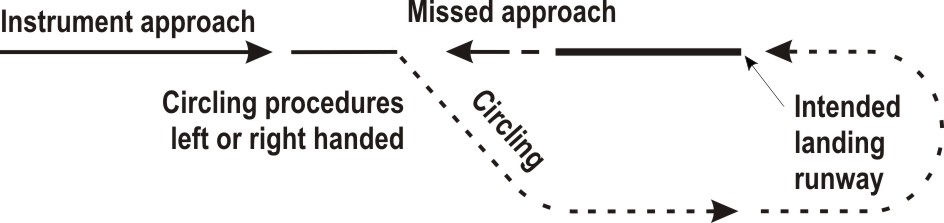
The pilot of an IFR flight shall follow the general procedures for IFR flights (see ENR 1.3 paragraph "Communication Failure"). In addition, for arriving flights, the following communication failure procedures apply.
- Proceed according the current flight plan route to BUDIP.
- Maintain the last cleared and acknowledged flight level.
- After arrival over BUDIP, intercept the holding pattern.
- Commence descent to 3000 FT AMSL at, or as near as possible to, the ETO over BUDIP.
- After reaching 3000 FT AMSL leave BUDIP and carry out an instrument approach procedure to RWY 21 (see chart IAC RNP RWY 21).
- Proceed according the current flight plan route to BUDIP.
- Maintain the last cleared and acknowledged flight level.
- After arrival over BUDIP, intercept the holding pattern.
- Commence descent to 3000 FT AMSL at the EAT last received and acknowledged.
- When no EAT has been received and acknowledged, commence descent to 3000 FT AMSL at, or as near as possible to, the ETO over BUDIP.
- After reaching 3000 FT AMSL leave BUDIP and carry out an instrument approach procedure to RWY 21 (see chart IAC RNP RWY 21).
See the instrument approach chart IAC RNP RWY 21.
Note:
This procedure is different from ICAO Doc 8168 Volume I (PANS-OPS).
|
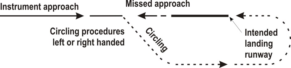
Authorisation required, see EHBD AD 2.22 paragraph 2.1.1.
Note:
recommended navaid for selection of MAG station declination only.
Note:
for positions of EH waypoints see instrument approach chart AD 2.EHBD-IAC-21.
| Serial number |
Path
descriptor |
WPT ident | Fly-over |
Course/Track
°MAG / (°T) |
Recom. navaid | Dist. (NM) | Turn | Altitude (FT / FL) |
Speed
(KIAS) |
VPA (°) / TCH (FT) |
NAV
specification |
|---|---|---|---|---|---|---|---|---|---|---|---|
| 001 | IF | BUDIP | - | - | - | - | - | @ 3000 | - 140 | - | - |
| 002 | TF | BD373 | - | 277 / (280.0) | - | 5.5 | - | + 2000 | - | - | RNAV 1 |
| 003 | TF | BD374 | - | 208 / (210.3) | - | 3.6 | - | + 2000 | - | - | RNAV 1 |
| 004 | TF | THR 21 | Y | 208 / (210.3) | - | 5.8 | - | - | - | - 3.00 / 50 | RNP APCH |
| 005 | FA | - | - | 208 / (210.3) | MAS | - | - | @ 700 | - | - | RNAV 1 |
| 006 | DF | BD375 | - | - | - | - | R | @ 700 | - | - | RNAV 1 |
| 007 | TF | BD376 | - | 027 / (029.6) | - | 6.3 | - | - 1200 | - | - | RNAV 1 |
| 008 | TF | BD377 | - | 087 / (089.6) | - | 8.9 | - | + 2000 | - | - | RNAV 1 |
| 009 | HM | BUDIP | - | 350 / (352.4) | - | 1.3 | L | + 2000 | - | - | RNAV 1 |
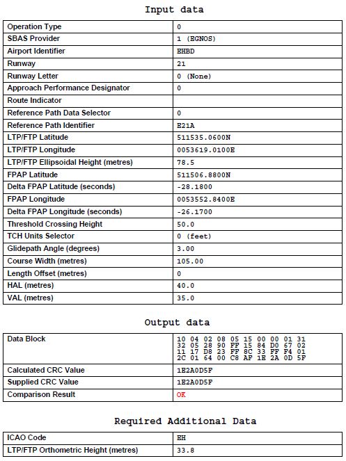
Note:
joining and leaving the circuit shall take place as depicted on the visual approach chart (see chart VFR TFC circuits).
Pilots are urgently advised to adhere strictly to the procedures prescribed and to keep a sharp look-out for military aircraft approaching Kleine-Brogel AD. These aircraft cross the circuit area at a minimum altitude of 1700 FT AMSL (1586 FT AAL).
- Approaches to the aerodrome shall be made strictly at 1100 FT AMSL (986 FT AAL) (see caution above).
- The circuit altitude is 814 FT AMSL (700 FT AAL).
- The visual traffic circuit must be carried out within the lateral limits of the circuit area appropriate to the runway in use.
- Be aware of MLA operating in the circuit southeast (parallel) of the runway.
- Built-up and marked areas shall be avoided as much as possible.
- Joining and leaving the circuit-area shall be done in accordance with the procedures on the chart VFR TFC circuits.
- The circuit height is 414 FT AMSL (300 FT AAL).
- The exit and entry heights of the MLA are 414 FT AMSL (300 FT AAL).
- The climb and descent area of the MLA is situated south of the Zuid Willemsvaart.

To be developed.