GEN 3.2 AERONAUTICAL CHARTS
1 RESPONSIBLE SERVICES
All the aeronautical charts are published under authority of the Aeronautical Information Services.
These charts are produced in accordance with specifications set down in ICAO Annex 4 and other pertinent ICAO Documents.
2 MAINTENANCE OF CHARTS
Revision of the aeronautical information on all charts is constantly in progress and amended reprints are published as regularly as production resources permit.
Topographical and hydrographical information portrayed is also revised when necessary.
3 PURCHASE ARRANGEMENTS
All charts are incorporated in the AIP Netherlands, except for the Aeronautical chart the Netherlands - ICAO 1:500 000; this chart is obtainable from:
Koninklijke Nederlandse Vereniging voor Luchtvaart (KNVvL)
Houttuinlaan 16A
3447 GM Woerden
The Netherlands
Tel: +31 (0)348 437 060
Email: [email protected]
4 AERONAUTICAL CHART SERIES AVAILABLE
4.1 The following series of aeronautical charts are produced:
- Aerodrome/heliport chart (ADC).
- Aerodrome ground movement chart (GMC).
- Aerodrome obstacle chart type A (AOC).
- Aircraft parking/docking chart (APDC).
- Area chart (AREA).
- ATC surveillance minimum altitude chart (SMAC).
- Instrument approach chart (IAC).
- Precision approach terrain chart (PATC).
- Standard arrival chart - instrument (STAR).
- Standard departure chart - instrument (SID).
- Visual approach chart (VAC).
- En-route chart (ENR).
- Aeronautical chart - ICAO 1:500 000.
4.2 General description of each series
- Aerodrome/heliport chart
This chart contains detailed aerodrome data to provide flight crews with information that will facilitate the ground movement of aircraft:- from the aircraft stand to the runway; and
- from the runway to the aircraft stand;
- from the helicopter stand to the touchdown and lift-off area and to the final approach and take-off area;
- from the final approach and take-off area to the touchdown and lift-off area and to the helicopter stand;
- along helicopter ground and air taxiways; and
- along air transit routes.
- Aerodrome ground movement chart
This chart is produced for aerodromes where, due to congestion of information, details necessary for the ground movement of aircraft along the taxiways to and from the aircraft stands and for parking/docking of aircraft cannot be shown with sufficient clarity on the aerodrome chart. - Aerodrome obstacle chart type A
This chart contains detailed information on obstacles in the take-off flight path areas of aerodromes, and shown in plan and profile view. - Aircraft parking/docking chart
This chart is produced for aerodromes where, due to the complexity of the terminal facilities, the information to facilitate the ground movement of aircraft between the taxiways and the aircraft stands and the parking/docking of aircraft cannot be shown with sufficient clarity on the aerodrome chart or on the aerodrome ground movement chart. - Area chart
This chart provides flight crew with information to facilitate the following phases of instrument flight:- the transition between the en-route phase and approach to an aerodrome;
- the transition between take-off/missed approach and en-route phase of flight; and
- flights through areas of complex ATS routes or airspace structure.
- ATC surveillance minimum altitude chart
This chart provides information that will enable flight crews to monitor and cross-check altitudes assigned by a controller using an ATS surveillance system. - Instrument approach chart
This type of chart is produced for each instrument approach procedure, and includes information on radio communication facilities and navigation aids, minimum sector altitude, procedure track in plan and profile view etc. The charts provide the flight crew with information that will enable them to perform an approved instrument approach procedure to the runway of intended landing including the missed approach procedure and associated holding patterns. - Precision approach terrain chart
This chart is produced for all precision approach CAT II and III runways. It provides detailed terrain profile information, in plan and profile view, within a defined portion of the final approach so as to enable aircraft operating agencies to assess the effect of the terrain on decision height determination by the use of radio altimeters. - Standard arrival chart - instrument (STAR)
This type of chart provides the flight crew with information that will enable them to comply with the designated standard arrival route - instrument from the en-route phase to the approach phase. - Standard departure chart - instrument (SID)
This type of chart provides the flight crew with information that will enable them to comply with the designated standard departure route - instrument from the take-off phase to the en-route phase. A general view of the SIDs established per aerodrome is produced as a supplement to the standard departure chart - instrument. - Visual approach chart
This type of chart is produced for those aerodromes used by civil aviation where:- only limited navigation facilities are available; or
- radio communication facilities are not available; or
- visual approach procedures have been established
- En-route charts
This type of chart is produced for the entire Amsterdam FIR. The aeronautical data include the air traffic services system. The charts provide the flight crew with information that will facilitate navigation along ATS routes in compliance with air traffic services procedures. - Aeronautical chart - ICAO 1:500 000
This chart is constructed on Lambert Conformal Conic projection with two standard parallels on 493320N and 530640N according the world geodetic system WGS 84. The intention of the chart is to provide topography and aeronautical data to satisfy the requirements of visual air navigation for low speed, short or medium range operations at low and intermediate altitudes.
5 LIST OF AERONAUTICAL CHARTS AVAILABLE
5.1 Aeronautical charts contained in the AIP
5.1.1 Aerodrome/heliport chart
See section AD 2.24 or AD 3.23 of relevant aerodromes/heliports.
5.1.2 Aerodrome ground movement chart
See section AD 2.24 of relevant aerodromes.
5.1.3 Aerodrome obstacle chart type A
See section AD 2.24 of relevant aerodromes.
5.1.4 Aircraft parking/docking chart
See section AD 2.24 of relevant aerodromes.
5.1.5 Area chart
See section AD 2.24 or AD 3.23 of relevant aerodromes/heliports.
5.1.6 ATC surveillance minimum altitude chart
See section AD 2.24 or AD 3.23 of relevant aerodromes/heliports.
5.1.7 Instrument approach chart
See section AD 2.24 or AD 3.23 of relevant aerodromes/heliports.
5.1.8 Precision approach terrain chart
See section AD 2.24 of relevant aerodromes.
5.1.9 Standard arrival chart - instrument
See section AD 2.24 or AD 3.23 of relevant aerodromes/heliports.
5.1.10 Standard departure chart - instrument
See section AD 2.24 or AD 3.23 of relevant aerodromes/heliports.
5.1.11 Visual approach chart
See section AD 2.24 or AD 3.23 of relevant aerodromes/heliports.
5.1.12 En-route charts
See ENR 6.
5.2 Other charts
5.2.1 Aeronautical chart - ICAO 1:500 000
Available in print (see also paragraph 3) and online via https://www.lvnl.nl/aip.
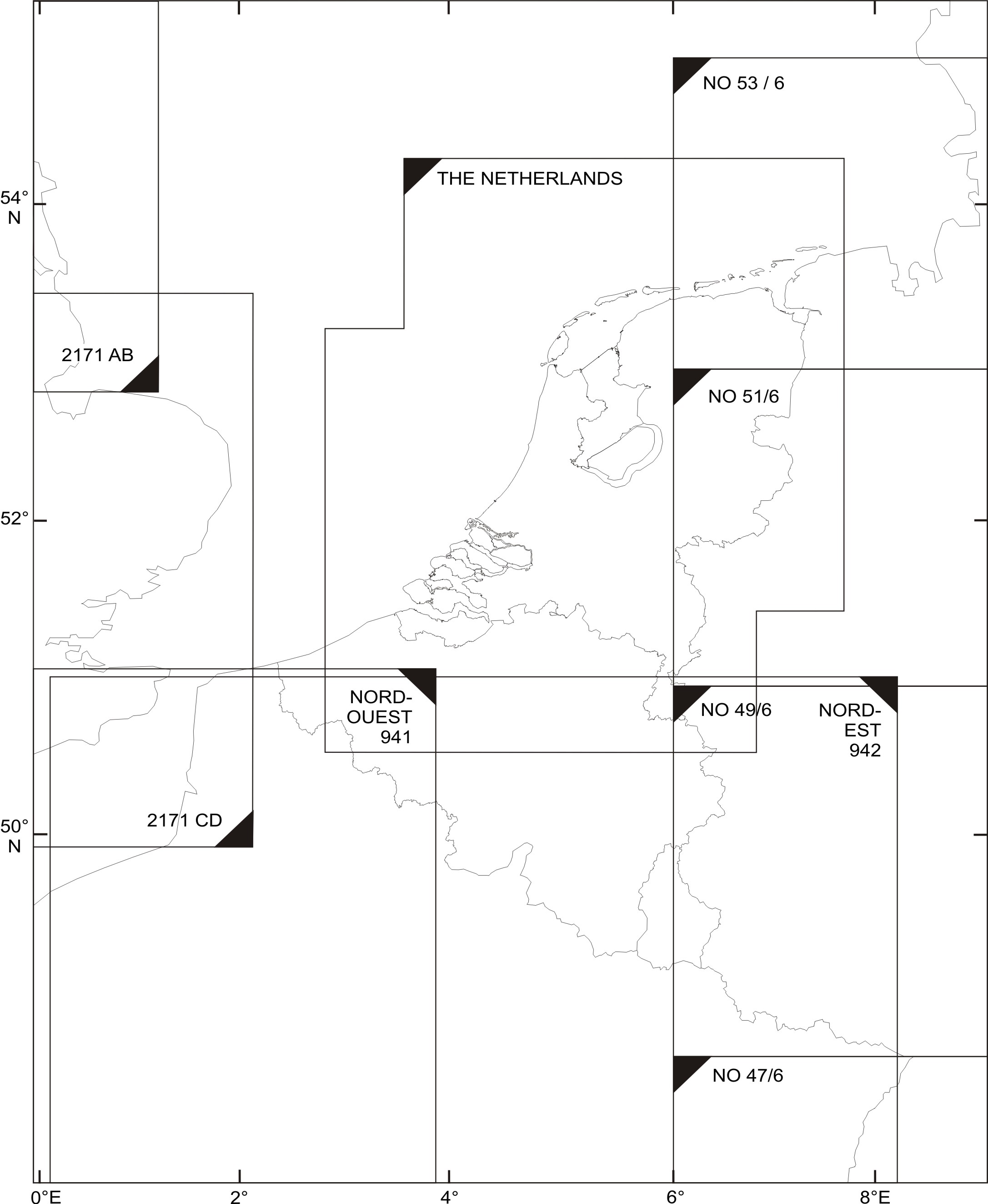
6 INDEX TO ADJOINING SHEETS OF THE AERONAUTICAL CHART - ICAO 1:500 000
7 TOPOGRAPHICAL CHARTS
Topographical charts and information are available from:
Kadaster
Klantcontactcenter
P.O. Box 9046
7300 GH Apeldoorn
The Netherlands
Tel: +31 (0)88 183 2200
Fax: +31 (0)88 183 2050
Email: [email protected]
8 CORRECTIONS TO CHARTS NOT CONTAINED IN THE AIP
Aeronautical information on the Aeronautical Chart ICAO 1:500.000 outside the Amsterdam FIR is published under reservation. For latest information on the adjacent FIRs consult appropriate AIPs and NOTAM.
| Charts | Location | Corrections |
|---|---|---|
| Aeronautical chart ICAO 1:500 000 Edition 2024 (13 JUN 2024) | 512633N 0033459E | Vlissingen, insert symbol heliport. |
| 524114N 0062949E | Alteveer, insert symbol hangglidersite, MAX cable HGT 15. | |
| 532730N 0035416E | Delete heliport K12-C. | |
| 532335N 0041203E | Delete heliport L10-C. | |
| 532833N 0034714E | Delete heliport K12-A | |
| 523614N 0062119E | Balkbrug, insert symbol hangglidersite, MAX cable HGT 15. | |
| 534215N 0043608E | Delete heliport L5-B. | |
| 533824N 0043345E | Delete heliport L8-P. | |
| 524643N 0041600E | Delete heliport Q4-A. | |
| 524259N 0041759E | Delete heliport Q4-B. | |
| APRX 5135N 00535E | EHTRA12, amend lower limit FL 095 to read FL 115. | |
| BTN 5111N 00558E and 5105N 00600E | Maastricht TMA, remove line airspace class B, C, D. | |
| APRX 513902N 0042131E | Add 4 wind turbines (area), ELEV 672 FT AMSL, lighted. | |
| APRX 523641N 0053803E | Add 24 wind turbines (area), ELEV 621 FT AMSL, lighted. | |
| APRX 513538N 0035208E | 3 wind turbine (line), change ELEV into 656 FT AMSL. | |
| APRX 515744N 0035754E | Add 22 wind turbines (area), ELEV 614 FT AMSL, lighted. | |
| 521402N 0062555E | Add symbol hangglider site (S15). | |
| APRX 524854N 0050116E | Delete microlight aircraft site symbol. Add aerodrome information box for EHMM. See AD 2.EHMM. | |
| 524701N 0061217E | Add EHR68, radius 300 M, upper limit 700 FT AMSL, lower limit GND. | |
| 531009N 0055230E | Warstiens, insert symbol microlight aircraft site. | |
| APRX 514311N 0043611E | Add 4 wind turbines (area), ELEV 676 FT AMSL, lighted. | |
| 515517N 0042842E | Add obstacle, ELEV 380 FT AMSL, lighted. | |
| 515818N 0040014E | Add obstacle, ELEV 381 FT AMSL, lighted. | |
| 541010N 0052605E | Delete heliport G14-B. | |
| 532027N 0035337E | Delete heliport K12-B. | |
| APRX 523846N 0064325E | Add symbol wind turbine ELEV 567 FT AMSL, lighted. | |
| APRX 523414N 0061340E | Add symbol wind turbine ELEV 666 FT AMSL, lighted. | |
| APRX 525532N 0063106E | Delete symbol hangglidersite. | |
| 515807N 0035935E | Add obstacle, ELEV 466 FT AMSL, lighted. | |
| APRX 522857N 0054652E | Change obstacle (line) ELEV into 777 FT AMSL, lighted. | |
| APRX 522849N 0054125E | Change obstacle (line) ELEV into 787 FT AMSL, lighted. | |
| APRX 522840N 0053811E | Change obstacle (line) ELEV into 695 FT AMSL, lighted. | |
| 522026N 0045249E | Add obstacle, ELEV 341 FT AMSL, lighted. | |
| APRX 522723N 0054409E | Add obstacle, ELEV 804 FT AMSL, lighted. |
| Chart | Location | Corrections |
|---|---|---|
| Aeronautical chart ICAO 1:500 000 Edition 2025 (20 MAR 2025) | 520358N 0042020E | Add obstacle, ELEV 512 FT AMSL, lighted. |
| 532027N 0035337E | Add heliport K12-B. | |
| 533303N 0034646E | Add heliport K9-AB-B. |